Retracing the road to historic Fort Smith
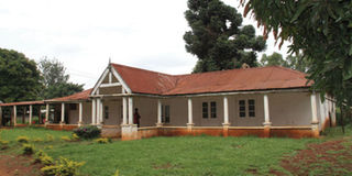
PHOTO | JOHN FOX The house on the Fort Smith site.
What you need to know:
- Fort Smith has some historical significance. But no Kenyans I asked knew about it. Fortunately, Google Maps does know
It is just over a year ago that my two sons and I drove Mzee, our old rebuilt Range Rover, from Nairobi to Karongwe in the north of South Africa. No Going Places pieces have stirred as much interest.
It seems we failed to communicate how easy the trip was: the crucial insurance carnet from the Kenyan AA was not difficult to get; the only potholes we encountered were in Kenya; no border crossing took more than 90 minutes; we dipped into our spare petrol cans only once; there was plenty of accommodation all along the way.
Only last week a guy was telling me that it was his dream drive, and he was pressing me for more information about the challenges — of bureaucracy, logistics, security — that he assumed he would have to face. And yet he had made a much more hazardous drive: up to the Matthews Range in northern Kenya, across the Chalbi Desert, to Lake Turkana.


My own first drive in Kenya was certainly much rougher. It was in 1967; we had brought out on the boat one of my best ever cars — a Ford Cortina GT — bright red, with a dashing black flash along the sides of the bonnet.
Nervy off-loading
After the nervy off-loading at Kilindini, we set off early morning for Nairobi. I have no memory of any traffic; there were elephants beside the road near Buchuma; the Tsavo Inn at Mtito Andei was offering a splendid buffet lunch — and then there was no tarmac from there until Hunters Lodge.
This got me thinking of how driving must have been in the “pioneering” days. Online, I found a typically witty work by Gavin Bennett, written in 1995: An Informal History of Motoring in Kenya.
Gavin begins with the story of George “Bwana Tayari” Wilson who, in December 1903, was the first man to import a car to Kenya — a Di Dion Bouton. At that time, writes Gavin, a determined pedestrian could go further without breaking down, an ox-wagon could carry more cargo, a horse-drawn carriage was more comfortable, and a mule was quicker to start up and a great deal cheaper to run. There were no garages, no petrol pumps — and only one major road in the country.
It was that reference to a “major road” that got me thinking — and reading — a bit further. Whatever roads existed in 1903 were little more than the dirt tracks of the old caravan routes: from the Coast, crossing the Taru desert scrubland, through the Kikuyu highlands, down into and along the Rift Valley and west to the Nile Basin.
It took another 23 years after Wilson’s off-loading before the first car actually made the journey from Mombasa to Nairobi. And, as Gavin, says, if Wilson had planned an inland trip, he would have plotted a route along the caravan trails and through a series of mission stations or forts that had been set up in the late 19th century in the days of the Imperial British East Africa Company: stations such as Kibwezi, Machakos, Fort Smith, Naivasha, Eldama Ravine, Nandi and Mumias.
Somewhere in Kabete
I guess you will know all these places except, perhaps, Fort Smith. I knew only that it was somewhere in Kabete. To find out more, I went back to Stephen Mills’ book on the building of the railway: A Railway to Nowhere. He has an inset, pen-portrait of Fort Smith. It was constructed in 1892 by IBEA. It had a stockade 25 feet wide, surrounded by a deep ditch. It contained, Mills writes, the first brick house in East Africa — made from local clay.
The fort was named after an IBEA officer, Major John Smith, who built it. Another officer, Francis Hall (the founder of Fort Hall, now Murang’a) and Chief Kinyanjui planted a fig tree they called the Tree of Peace. It was to commemorate the patching up of Anglo-Kikuyu relations.
Google Maps
So Fort Smith has some historical significance. But no Kenyans I asked knew about it. Fortunately, Google Maps does know. So we were able to plot the route: along Waiyaki Way to the Uthiru roundabout; north along the Kapenguria Road; first right at Ndumbuini into an unmarked dirt road — and the site of Fort Smith is up the hill and on the right, a few metres past Junel Primary School.
The old fort was replaced by a private house in the low-slung colonial style. The Tree of Peace is still there. Across the road, down the hill and almost hidden in a maize patch, there are some graves of IBEA and Uganda Railway officials, dating back to 1898.
Along the dirt road, we asked a number of people for directions, but only a mzee knew the place, calling it “kwa mzungu”. Once there, we found the site unkempt and uncared for.
Our friend, Peter Kamau, had joined us on the quest.
“It just shows how easily history can disappear,” he said.
John Fox is Managing Director, iDC