Museveni: You got me wrong on Migingo
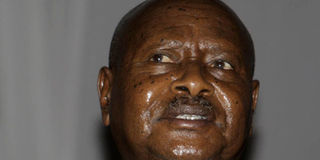
Uganda's President Yoweri Museveni. He has told a news conference, attended by Kenyan media, that he is committed to resolve Migingo Island row through the ongoing border survey. Photo/FILE
What you need to know:
- President Museveni says it is Suba Island, which is in Kenya with the Uganda border just a foot from the shoreline, and not Migingo.
- He insists Kenya Minister for Lands Mr James Orengo should apologise for allegedly describing Ugandans in derogatory terms.
Uganda President Yoweri Museveni has told a news conference that he is committed to having border disputes with Kenya resolved through an ongoing survey.
He said it is Suba Island, which is in Kenya with the Uganda border just a foot from the shoreline, and not Migingo as had been reported in the media.
But, he is confident Kenya and Uganda will resolve the dispute in the spirit of the East Africa Cooperation without having to involve outsiders.


President Museveni says his words broadcast by the BBC Radio’s Africa Service have been misconstrued, adding that his references to “wajaluo” was never meant to despise anybody, not even the Luo tribe in Kenya.
However, the Ugandan leader insists Kenya Minister for Lands Mr James Orengo should apologise for allegedly describing Ugandans in derogatory terms.
He added that Kenyans should also apologise for blocking the flow of Ugandan goods recently when rowdy youths sabotaged the railway line in Nairobi’s Kibera slums and also during the 2007 post-election violence.
His remarks comes a day after he issued an invite to Kenya media to cover his press conference in Uganda over the controversial issue.
President Museveni's remarks affirm those of his spokesman Fred Opolot issued on Tuesday to the effect that the president was quoted out of context and never meant to hurt anyone. Mr Opolot was referring to Museveni's "wajaluos are mad" remark in reference to the Luo community.
“The statement was misconstrued, misunderstood and taken out of context... the reason he made reference was the reason that they (British Broadcasting Corporation) are the ones who brought up the issue,” Mr Opolot said.
During his Monday lecture in Dar es Salaam, Tanzania, President Museveni said Kenyans would not be allowed to fish in the waters of the island.
“The island is in Kenya, the water is in Uganda. But the Wajaluos are mad, they want to fish here but this is Uganda... hii nchi huru (this is a sovereign country). It is written here in English... from this point, the border will continue to go in a straight line to the most northern point of Suba Island. Mpaka inazunguka kisiwa (the border surrounds the island)... one foot into the water and you’re in Uganda,” President Museveni said.
He added: “So, I have been telling those Jaluos who were rioting... wanang’oa (uprooting) railway... see, I want to discuss with them... if we implement this hakuna mjaluo atavua samaki (no Luo will fish) in this water.”
On Wednesday, Kenya MPs reacted angrily to Museveni's remarks, terming him "an exapnsionist".
The MPs, mainly backbenchers, demanded that the Kenya Government explain the relationship between the two countries.
They demanded that the Kenya Government act firmly and with resolve against what they said was a creeping military occupation of Kenyan territory.
The MPs said the government should act without delay to protect Kenya’s territorial integrity. They termed the remarks provocative and insulting, describing Uganda as a “hostile” state.
The Migingo survey, led by a team of experts, started work on Monday.
Leading the team are Kenya's director of lands, Mr Ephantus Murage, and his Ugandan counterpart, Mr Justin Buogi.
The exercise is expected to end in two months.
Foreign Affairs minister Moses Wetang'ula and Uganda's third Deputy Prime Minister Kirunda Kivejinja said that the identification of the boundary would settle the dispute over the island.
They said an independent contractor would be invited in case of disagreement.
Mr Wetang’ula said the exercise was not specifically meant to establish whether the island was Kenyan or Ugandan, but was for compliance purposes to an international requirement.
He said the results of the survey and revised maps will be deposited with the United Nations as per a requirement that dictates all revised boundaries must be tabled with the UN by 2012.
Up to Sh140 million has been earmarked for the joint border survey.