Breaking News: At least 10 feared to have drowned in Makueni river
Why Migingo survey stalled
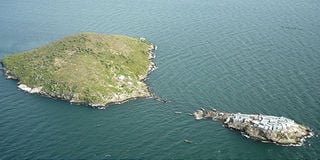
Migingo Island (right) as it stands on Lake Victoria.PHOTO/FILE
What you need to know:
- Uganda wants two border lines drawn, which would place the island in their soil
Differences in interpretation of a joint communiqué on the disputed Migingo Island led Ugandans to pull out of the process.
The stalemate arose when the Ugandans led by Justin Buogi failed to convince the Kenyan team led by Ephantus Murage to draw two lines as the boundary between the two countries, yet as experts they were to determine the correct border line.
It is paragraph six of the communiqué that has now become a bone of contention, the Saturday Nation has established.


To the two islands
It reads: “In determining the location of Migingo Island, the survey team is informed by arguments from both sides on which of the two islands next to Migingo constitute the Pyramid Island. In this regard, straight lines shall be drawn from Remba Island to the two islands.”
It has now emerged that Uganda disputes which island is Pyramid.
However, a senior official from Kenya’s Lands ministry, who sought anonymity because he is not authorised to speak on behalf of the ministry, says the available maps with the support of coordinates from the 1926 Order in Council were clear over which island is pyramid.
The Ugandan team insists on drawing two lines from Remba, also known as Ilemba Island, one to Ugingo Island and the other to Pyramid. The line to Ugingo will place Migingo in Uganda while the one to Pyramid places it in Kenya.
But the Kenyan team failed to understand the need to draw the two lines since available records show that the border line moves from Remba Island straight to Pyramid Island, whose coordinates are given in the 1926 Order in Council.
The communiqué from a ministerial meeting between the two countries was signed on May 11 following a meeting to launch the survey.
It was signed by Kenya’s Foreign Affairs Minister Moses Wetang’ula and Uganda’s Minister for Internal Security Kirunda Kivejinja.
To try and unlock the stalemate, Uganda’s minister for Foreign Affairs Sam Kutesa is scheduled to come to Kenya early next week to meet with Mr Wetang’ula.
The two are expected to agree on a correct interpretation of the report guiding the surveyors from the two countries.
Mr Wetang’ula told the Saturday Nation he is likely to meet Mr Kutesa in Lusaka on Saturday.
Preliminary findings show that the disputed Migingo is 510 metres inside Kenya. This has been determined in relation to Ilemba and Pyramid Islands as described in 1926 Order in Council. Migingo Island is 1.5 acres.
Kenyan authorities now feel that there is need for the two teams to do a joint report of the first phase before starting the second phase.