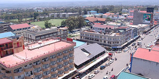
Nakuru booms as its population surges
Joseph Kiheri | NATION
Nakuru Town is the fastest growing town in East Africa, according to UN-Habitat.
What you need to know:
- Despite a number of challenges, the town cashes in on politics
For a town whose property value has quintupled in five years, Nakuru is steadily transforming from the traditional farming town it has been to a commercial hub.
Rift Valley’s fastest growing town is now playing host to some 30 bank units including top ‘club’ banks with Central Bank set to open a new centre soon.
The return of the old county regions will have many advantages for Nakuru whose road network into all its former districts, enables efficient transport and communication.


Besides, Nakuru is centrally located for travellers accessing the western part of the country and the neighbouring nations of Uganda, Southern Sudan, Rwanda and Burundi.
For the once small town in the heart of South Rift, the events of the post-election violence of 2008 became a blessing in disguise, as anxious business owners shifted in big numbers into the town from affected regions and immediately set up shop.
“There was an influx of people into the town, mostly business owners who had investments elsewhere, and did not wish to go back, choosing to invest here,” said Mr Charles Kariuki, valuer and land development consultant with Applecross Surveyors.
Urging Kenyans to shed the mind-set that Nakuru is still the small farming town, director of Town Planning, Willy Keter, says that in a day he gets applications from at least 15 new people seeking to either convert a user area from residential to commercial status or for some yet to be constructed building.
He adds that a number of blocks in the town that were previously residential are being turned to commercial status as a part of measures to expand the town.
“Areas such as along Oginga Odinga road and the block 15 area, which have been middle density areas, will be converted for high density development, to allow for expansion,” says Mr Keter.
According to information on the municipal council’s website, the larger town’s population is concentrated within the existing municipal boundary, with the highest densities found in the public housing triangle that consists of Langalanga, Freehold, Shabab, and Kenlands estates, Kaptembwa and Central Business District.
These areas have well-established, serviced and accessible housing estates south of the central business district, and the main industrial area. Most community facilities are already provided in these areas, with water and sewage disposal services in full service.
“These are the estates that will attract tenants because they hardly lack water and other basic amenities, which make the area a comfortable option for many who are moving to the town,” he adds.
Another area with high population concentration is located directly north and south of the eastern industrial area, better known as Nakuru Blankets. These residential areas include Karatina and Free Area housing estates.
The concentration of population in this area is due to the availability of cheap land for housing development through private initiatives.
These estates are, however, are not well serviced and lack basic support and essential community facilities such as, schools, hospitals and recreational facilities.
Population in peri-urban areas, such as, Ngata, Engashura, Mbaruk, Worker’s, Kiamunyeki, Wanyororo, Kiambogo, is also increasing significantly.
Areas with relatively lower population densities include Naka, which lies in block 14 and block 17 lacks services that would attract settlement, while residential areas of Milimani and Lanet have low population densities due to the size requirements that should be kept when land owners are sub-dividing land for sale.
“What we lack in Nakuru presently is the formation of residential associations, which would help the council in issues of building constructions, a problem that the town has to shoulder, especially for land owners who put up property that goes against requirements within the particular area, which may not necessarily be unlawful, but would bring discomfort to others living in the place.”
According to Mr Keter, the town’s plan for expansion was well documented at the beginning of the millennium when the United Nations Habitat presented a plan for it.
However, he says, for many years it has not had a planning department to implement the UN Habitat plan, but a council department was recently set up and is now down to work, implementing the details of the original plan for expansion.
“I am in charge of cascading the expansion plan into blocks from block 1 to 30, and making sure the policies regarding development within each zone are followed to the letter,” says Keter. A number of blocks within the central business district are undergoing the upgrading programme to take the commercial status.
The council is also working in partnership with the World Bank to cater for non-motorised forms of transportation within the town, such as the bicycles, tricycles commonly known as Tuk Tuks and motorcycles.
“There are thousands of Boda Boda operators earning a livelihood from the trade. The council came up with a plan to have them in designated parking areas but this does not make business sense for them.