Counties’ vicious fight to control billions
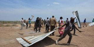
Residents destroy barriers and makeshift structures used by police officers at Ngaremara in Isiolo in September. They claimed the officers were collecting money for Meru County government. Such boundary disputes have become rampant among the devolved units. FILE PHOTO | KENNEDY KIMANTHI |
What you need to know:
- The disagreements have been heightened by recent discovery of oil and minerals in various regions, as well as the launch of projects linked to Vision 2030.
- On Wednesday, the government announced it will put up visible landmarks including beacons, road signs and other conspicuous symbols in all county boundaries to settle the growing number of disputes.
Counties across the country are embroiled in vicious boundary disputes over resources which could run into hundreds of billions.
The disagreements, some of which have turned bloody, have been heightened by recent discovery of oil and minerals in various regions, as well as the launch of projects linked to Vision 2030, which soared the expected windfall.
On Wednesday, the government announced it will put up visible landmarks including beacons, road signs and other conspicuous symbols in all county boundaries to settle the growing number of disputes.


The protracted border dispute between Meru and Isiolo counties, which has seen Governor Peter Munya’s convoy stoned, has been linked to the Lamu Port and South Sudan-Ethiopia Transport (Lapsset) corridor which is expected to pass through Ilat, Chumvi Yarre, Gambella, Tractor and Kisima.
Both counties have laid claim to the disputed regions which are seen as key to their own development because of their potential in terms of revenue collection.
The area is situated in Nyambene Conservancy and is inhabited by the Meru, Turkana, Somali, Samburu and Borana.
But despite the Independent Electoral and Boundaries Commission, the National Lands Commission and the Land and Interior ministries being mandated to resolve the issue in December last year, the technical process of marking the boundary is yet to begin.
“The process was set to begin in March this year, but we have seen no efforts on the side of the government. Now no development can take place because it was resolved that the status quo be maintained until the boundary is determined,” Mr Munya told the Saturday Nation on Friday.
The governor’s convoy was attacked after he ordered the removal of a barrier at Ilat where the Isiolo County government had erected a tax-collection point.
Governor Godana Doyo believes that the boundaries between the former Meru and Isiolo districts were marked in 1962 without the participation of the people of Isiolo due to the Shifta secessionist war with Somalia.
Meanwhile, a simmering row between Meru and Tharaka Nithi threatens to get out of hand at Mukothima and Ntoromi where the Tharaka residents accuse their Igembe counterparts of settling on their land.
Tharaka Nithi Assembly Committee on Planning, Trade and Cooperatives chairman Albano Kiania told the Saturday Nation by phone that the slow adjudication and title deed issuance occasioned by the dispute has led to huge losses.
On Monday, a sand trader was shot dead in an attack linked to the dispute at Ndumuru in Igembe North.
SCHOOLS 'LEGITIMISE INVASION'
At the Coast, Kwale Governor Salim Mvurya and Taita Taveta’s John Mruttu are yet to come up with an amicable solution in the dispute at Mackinnon Road.
The issue has still remained unsettled even after the governors had a joint meeting at Tsavo National Park 10 months ago.
Elsewhere, Kitui and Tana River counties are feuding over the area around the expansive South Kitui game reserve.
Three primary schools built in Kitui by Tana River leaders four years ago are the main cause of the border quarrel.
Kitui leaders have accused their Tana River counterparts of encouraging their people to violate the boundaries by establishing schools to legitimise invasion.
MPs Joe Mutambu (Mwingi Central) and Rachael Nyamai (Kitui South) claimed that building schools using CDF amounted to legitimising the grabbing of sections of Kitui County.
“Our two communities have co-existed peacefully since independence and the boundary issue should not be allowed to bring animosity and mistrust,” Galole MP Hassan Dukicha said, adding that youth from both sides should access direct and indirect jobs at the ongoing multi-billion Lapsset corridor project.
BLAME MAP
In Turkana and West Pokot, the flashpoint is River Turkwel and the hydro-electric power project.
The tussle has often turned violent and has in recent months rendered Kapenguria-Lodwar Highway impassable especially between Marich and Kainuk.
“The fresh fights are no longer about stealing of animals but the Pokot want ownership of land on both sides of the two rivers (Kerio and Turkwel) because of its fertility,” said Ms Joyce Emanikor, the chairperson of Kerio Valley Development Authority (KVDA).
The Pokot blame a 1992 map by the KVDA, to earmark areas for its development plans, which they say alienated the community during its formulation where a huge chunk of ‘their’ land was hived off.
“We know the government has the machinery to deal with this (boundary) issue once and for all, with a series of meetings between elders from the two communities as they are better placed to understand exactly what has transpired all these years,” observes West Pokot Senator John Lonyangapuo.
But the Turkana do not agree with their Pokot neighbours on the ownership of land along rivers Kerio and Turkwel.
“Leaders should stop misleading the public, I recall clearly the late Energy Minister Francis Lotodo saying at the Turkwel hydro-power plant and the hills are in West Pokot while the plains are in Turkana,” Turkana Senator John Munyes said this week.
In Laikipia and Nyandarua, leaders cannot agree on who should lay claim on Nyahururu town which has since independence served as Nyandarua’s headquarters.
Nyandarua leaders believe Nyahururu was built using money from its farmers and government funds meant for improving the lives of the locals.
Laikipia leaders contest the claim saying Nyahururu was managed by the defunct Nyahururu Municipal Council which is part of Laikipia.
Interestingly, Nyahururu remains politically in Laikipia County, but administratively it is run by civil servants answerable to Nyandarua.
The Nyandarua headquarters are however in Ol Kalou Town.
In Machakos and Makueni, both counties are laying claim to the Konza Technology City, another Vision 2030 project.
Reports by Kennedy Kimanthi, Kitavi Mutua, Arthur Situma, James Kariuki, Philemon Suter, Wycliff Kipsang and Farouk Mwabege