Wajir's Ajuran seek to block border identification report citing non-involvement
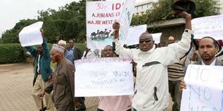
Members of the Ajuran community march along Parliament Road in Nairobi in June 2011 to protest the alleged grabbing of their land by the Degodia in Wajir West. The community will on September 19, 2016 sue to block the publication and adoption of a recent boundary identification report, saying they were not involved in the process. FILE PHOTO | NATION MEDIA GROUP
What you need to know:
- They want the court to direct that the boundary identification be conducted in an inclusive and transparent manner.
- They want to be given an opportunity to present their views to enable the surveyors to prepare an accurate and credible report.
- The British colonialists’ had initially divided Wajir into three settlements — Wajir East for the Degodia, Wajir West for the Ajuran and Wajir South for the Ogaden.
- Eldas constituency currently has a very small population and is equally relatively small in size, measuring approximately 4,077 square kilometres.
The Ajuran community, who are the majority in Wajir North constituency, plan to sue on Monday to stop the publication and adoption of a recent boundary identification report.
They say they want to be involved in the boundary identification process.
In their application, they claim that there has been a deliberate effort by the local administration to curve out part of the area under Wajir North constituency and add it to Eldas constituency, which is predominantly occupied by the Degodia community.


The petitioners have, on behalf of the Ajuran community, sued the regional coordinator of the Northeastern region, the Wajir County commissioner, the Interior Cabinet secretary, the Independent Electoral and Boundaries Commission (IEBC) and the Attorney-General.
UNFAIR PROCESS
“The manner the survey is being carried out is clearly an unfair manipulation of the boundary identification process for ulterior motives,” the Ajuran community's lawyer Julius Anyoka says in court papers.
They argue that two surveyors assigned to the boundary issue resorted to carrying out a new border identification with a view to legalising the controversial boundary identification report in favour of Eldas constituency.
They want the court to direct that the boundary identification be conducted in an inclusive and transparent manner, where they are given an opportunity to present their views to enable the surveyors to prepare an accurate and credible report.
There has been tension between residents of the two constituencies, with claims that the local leadership has orchestrated a systematic marginalisation of the Ajuran clan.
LOSS OF LIVES, PROPERTY
In 2015, tension between the two communities escalated, leading to fighting that claimed live, burning of houses and destruction and looting of property.
Eldas constituency, mainly inhabited by the Degodia community, was created in 2012 by the IEBC following a countrywide electoral and boundary review in which several other constituencies were also created.
The British colonialists’ had initially divided Wajir into three settlements — Wajir East for the Degodia, Wajir West for the Ajuran and Wajir South for the Ogaden.
In the court papers, the petitioners claim that since 1979, the Degodia slowly moved into Wajir West and dislodged the Ajuran community from political power and their ancestral land, resulting in fighting between the communities.
In a bid to resolve the long-standing boundary dispute and ease tension, President Daniel Moi's administration created Wajir North constituency, which was carved out of Wajir West constituency. Wajir North constituency became mainly occupied by the Ajuran.
The two communities thereafter enjoyed peace for nearly 20 years until 2009, when Eldas District was created and eventually Eldas constituency, which is sandwiched between Wajir West constituency and Wajir North constituency.
Eldas constituency currently has a very small population and is equally relatively small in size, measuring approximately 4,077 square kilometres.