Projects in the river basin shouldn’t foul up the environment
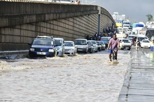
The River Tana Basin has been badly affected by developments upstream which, experts warn, could lead to disaster. PHOTO| FILE| NATION MEDIA GROUP
What you need to know:
- The Tana is a source of livelihood for many, with an estimated 8 million people living along its course, engaging in maize, tea, coffee, and other cash-crop farming.
- The water in the upper Tana is used mainly for drinking, industrial supply, agriculture and hydropower. Mwea, Kaggari-Gaturi-Kieni, Mitunguu, Bura, Hola, Tana Delta and Delmonte are some of the irrigation schemes in the Tana’s basin.
- The report indicates that, while providing socio-economic benefits in parts of the country, in others, especially downstream, it causes deprivation.
River Tana, probably more than any other river, has been pivotal to the country’s economic progress. It provides most of Nairobi’s drinking and industrial waters, and nearly half the country’s energy needs are met through hydropower, 77 per cent of which is supplied by the river and its headwaters. The country’s longest river, River Tana reaches the Indian Ocean at Formosa Bay in Kipini at the coast.
However, environmental conservationists warn that, if not properly managed, the development projects on the river could wreak havoc on its frail ecosystem and biodiversity.
Their assessments are contained in a report, The Economics of Ecosystem Services of the Tana River Basin, which was released in September last year. It notes that the river’s health and long-term ability to provide the services it has been providing is increasingly under threat, not just from the existing and planned diversion schemes and collection pans, but also from pollution and soil erosion due to poor land-use, among other threats.


The report analyses the developments planned within the basin and their benefits and looks at how to strike a balance between development and conservation of the basin’s ecosystems and human wellbeing.
A collaboration between Kenya, The Netherlands and a number of international bodies, the report specifically addresses Sustainable Development Goal 6: Ensure availability and sustainable management of water and sanitation for all.
It is a first step towards an integrated assessment of an extended cost-benefit analysis accounting for environmental and societal changes both upstream and downstream in the river basin and aims to provide guidance for optimum use of the Tana Basin waters.
SOURCE OF LIVELIHOOD
The Tana is a source of livelihood for many, with an estimated 8 million people living along its course, engaging in maize, tea, coffee, and other cash-crop farming.
The water in the upper Tana is used mainly for drinking, industrial supply, agriculture and hydropower. Mwea, Kaggari-Gaturi-Kieni, Mitunguu, Bura, Hola, Tana Delta and Delmonte are some of the irrigation schemes in the Tana’s basin.
The report indicates that, while providing socio-economic benefits in parts of the country, in others, especially downstream, it causes deprivation.
So although that developments in the river’s basin contribute to the country’s GDP, they have had serious negative effects on the ecological health of the river and affected the activities of various stakeholder groups.

Construction work at the Northern Collector Scheme Tunnel in Makomboki, Murang’a County. Environmental conservationists have warned that the tunnel, which is intended to supply Nairobi with and additional 140,000 cubic metres of water, will have negative effects on the Tana River Basin’s environment. PHOTO| FILE| NATION MEDIA GROUP
The report warns that the planned development projects in the river’s basin might have short-term gains but could lead to long-term losses resulting from the degradation of its ecosystem.
“Most of the benefits are accrued by upstream users, who are getting most of the water to drink and for electricity generation,” said Mr Frank Van Meert, senior technical officer, water and climate, Wetlands International,during the launch of the report. “The costs and benefits of large infrastructural works in the river basin are not equally distributed in space and time.”
The report says that the river, located in the south-eastern part of Kenya and traversing Murang’a, Kirinyaga, Embu, Tharaka, Kitui, Tana River, Lamu counties, parts of Nyeri, Garissa, Kiambu, Machakos and Nyandarua, benefits Nairobi county, which is not even in the basin, more than it does the basin counties.
The Tana basin supplies 80 per cent of the water consumed in Nairobi. Two dams, Sasumua, located uphill on the Aberdares on the Sasumua River and fed by the Sasumua and Chania rivers, and Ndakaini on Thika River fed by the Thika, Kayuyu and Githika rivers, supply the city’s water.
But the water is not enough for the expanding city’s rapidly growing population.
Nairobi County gets slightly more than half a million cubic metres per day against a demand of 700,000 cubic metres. The government plugs the approximately 200,000 cubic metre shortfall by drawing more water from the basin.
The report says that the upstream counties of Nairobi and Kirinyaga benefit most from the developments; for every dollar invested in the dams, $8 (Sh824) are returned in the form of electricity and water benefits within the counties. Meanwhile it describes Kitui, Tana River and Isiolo counties as the “losers”.
All downstream counties will suffer as a result of a proposed million-acre project, except for Tana River County, where most of the planned irrigation will take place.
In Murang’a county, for instance, only 33 per cent of the people have access to clean drinking water.
COST BENEFIT ANALYSIS
An extended cost-benefit analysis of the grid connection in the counties of the Tana River Basin hydropower showed that connection varies from 56 per cent access in Nairobi to only 4 per cent in Tana River County.
At least 91 per cent of the power generated by the dams is believed to serve upstream counties, with the remaining 9 per cent used by downstream beneficiaries.
The electricity supplied by the dams is estimated to be worth $400 million (Sh40.6billion) per year.
“Flooding volume and frequency have greatly decreased since the last power generation dam [at Seven Forks] was constructed in 1989,” the report notes.
The five dams have resulted in less variability in discharge, with a 20 per cent decrease in peak flows in May, and roughly a 70 per cent increase in low flows in February and March.
“The dams have generated abundant benefits for the upstream region in terms of electricity, potable water and agricultural outputs while the downstream region has lost more than it has gained,” Mr Van Weert pointed out.
The report shows that wetlands in the Tana River Basin are changing rapidly. For instance, the salinity range of the water flowing downstream gets affected by the frequency and duration of the reservoirs upstream.
“The size of the Tana Delta’s wetland dropped from 43,334 hectares in 2000 to 4,112 hectares in 2010, representing a 91 per cent loss in 10 years. The wetlands’ ecosystem services are being eroded and they are no longer able to provide services at levels that can sustain local communities,” cautioned Wetlands International Kenya Programme Manager Julie Mulonga.
It is such effects, coupled with an increase in dams drawing water from the Tana Basin, that have raised fears of over-abstraction of water in the basin.
Mr Van Weert said the planned projects upriver will greatly reduce the overall water resources in Garissa to almost a constant level of natural minimum flow, with hardly a flood peak left, leading to a drop in the mean discharge by about a third.
“If all these planned expansions fail to take account of the likely effects on natural systems, downstream livelihoods could be threatened,” he cautioned.
In spite of the anticipated economic benefits, the report indicates that future infrastructural developments in the Tana Basin will further stress it.
“Users downstream lose out because most of the water is being retained upstream. And these communities downstream depend on the flooding,” said Ms Mulonga.” “Besides the financial feasibility of additional dams, it is important that the indirect economic effects of hydro-electric and hydro-agricultural schemes on downstream ecosystems and beneficiaries be evaluated scientifically.”
Mr Joakim Harlin, chief, freshwater, UN Environment, noted that the poor are most at risk. “Analyses such as these, where the value of environment and ecosystem services are factored in, are essential for understanding opportunities and trade-offs for the sustainable management and development of the Tana River Basin. What we measure, we can manage. If we don’t measure and factor in the ecosystem and biodiversity services and the livelihoods that they provide into our development equation, then the picture is incomplete,” he said.
DILEMMA OF DEVELOPMENT
He noted that there were 14 years to go for Vision 2030, during which he hoped the implementation of the Tana Catchment Management Strategy would be undertaken.
“On a nationwide scale, you have to use your natural resources, but there are tradeoffs,” he said, adding, “How do we get a healthy balance? While it might generate more GDP for the country, will it have negative socio-economic and environmental effects? This is the dilemma of development but we have to get that balance right.”
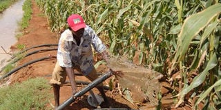
A man prepares pipes to irrigate a maize farm at the Bura Irrigation Scheme in Tana River County, one of the many projects that depend on the River Tana. PHOTO| FILE| NATION MEDIA GROUP
Mr Awadh Mbarak, a resident of Kipini, a smallvillage where the Tana River meets the Indian Ocean and member of the Kipini Community Conservation Management Forum said his village depends on fish that live and breed only in the mangroves of the Tana Delta. But with the mangroves destroyed, getting fish is almost impossible. The report estimates that the ecosystem services of mangroves in the Tana River Delta – which provide fish, firewood and flood protection – at $2.5 million; already, 38 per cent of the trees has been lost.
“We did not understand the connection between the reducing mangroves and the diminishing fish numbers, until the scientists came and enlightened us,” says Mbarak adding further diversion of water would affect flooding patterns in his village and affect the progress they had made in restoring the forest.
Since the 163,600-hectare Tana Delta biodiversity hotspot is also home to endangered species, it was designated a Ramsar site in 2012.
“Because mangroves need regular flooding of the delta to neutralise the potential salinity increment beyond the tolerable levels of the various species that inhabit the area, a better design of upstream dams and irrigation projects is needed to allow the ecosystem receive its fair share of the important resource input,” said the report.
Replanting of mangroves along the shorelines, particularly on the eastern/and northern side of Kipini, will help check coastline erosion.
Experts said it was in the interest of policy implementers to mitigate the negative effects on riparian communities.
***
CONTROVERSIAL PROJECT
Seeking more water for the city
The Northern Collector Scheme Tunnel (NCST), which is underconstruction, is envisaged to provide an additional 140,000 cubic metres of water daily to the city
The Sh6.8 billion channel, the third major water supply project in the basin, is expected to draw water from the Maragua, Gikie and Irati rivers in Murang’a Country.
Its construction has sparked controversy, with the Opposition claiming that the government tried to cover up its development for fear of resistance by environmentalists, but the Ministry of Water and Irrigation insists it did not, saying the project is on course and will be completed in 2018.
The waters will feed into the Ndakaini Dam— with a storage capacity of 70 million cubic metres —which is already being fed by other tributaries of the Tana.
Notably, the booklet on the commissioning of the NWCT project published by the Athi Water Services Board says the project will have no impact on the frequency of the river’s flow, but contradicts itself when it says that the cumulative impact of the project on hydro power generation downstream will be a 2.32per cent reduction in the mean annual inflow to the Masinga Dam.
Speaking during a tour of the site in Makomboki, Murang’a County last year, the Principal Secretary in the Ministry of Water and irrigation, Prof Fred Segor said: “This project will be utilising flood water, which would otherwise have flowed to the Indian Ocean. We are thus maximising on the water that will be channelled to the dam and then redistributed to residents both here in Murang’a and in Nairobi County.”
Interestingly, documents seen by DN2 indicate that the government paid Sh1.3 billion to the contractor of the NCTS almost two years before the project was approved by the National the Environment Management Authority (Nema).
OTHER PROPOSED DEVELOPMENTS
The 96 square kilometre High Grand Dam at Kivuka with a capacity of over 5.6 million cubic metres to serve the proposed Lamu Resort City and port, and also generate 500MW-700MW of electricity
A 1 million-acre irrigation scheme in Tharaka Nithi, Embu and Kitui counties.
Thiba Dam, with a capacity of 15.6 million cubic metres is planned on the Thiba River, which is served by rivers Nyamindi and Thiba, both of which drain into the Tana River
Additional irrigation in Bura, Hola and the Tana Delta.