At last, the country has a document to rationalise land use
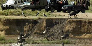
Tourists watching the annual wildebeest migration at the Maasai Mara. A major forex earner for the country, it is affected when humans encroach on wildlife territory, such as the man herding his cattle in the game reserve. PHOTO | FILE
What you need to know:
- Rural-urban migration has also resulted in serious land fragmentation and a steady decline in rich agricultural land, which is slowly shrinking as it gives way for more houses to cater for the growing demand.
- In the Masai Mara Game Reserve in the county, humans and wild animals constantly compete for resources. Rampaging elephants have made it very difficult for the local residents to farm, while the residents make it impossible for wild animals to roam freely by putting up fences.
- The game reserve also hosts approximately 25 per cent of Kenya’s wildlife, with 95 mammal and 550 bird species. It also offers hot air balloon tours and provides a setting for aerial and safari images with iconic landscapes of open grasslands, riverine forests, swamps, thickets and rocky.
Lack of planning of land and related resources has resulted in unequal distribution, underuse of areas considered low potential and overstretching of those believed to be high potential.
This has resulted in the depletion of resources in some areas, underuse of others, and even conflicts over the same, as witnessed recently in Nanyuki when pastoralist communities were seeking pasture and water for their animals in private conservancies.
It is notable that arid and semi-arid lands (ASAL) in the country, which are regarded as “low potential”, account for almost 56.34 per cent of the land. Agriculturally rich land that can support different types of mixed farming constitutes roughly 15.7 per cent, while about 27.6 per cent of land is considered environmentally sensitive and should be conserved.


This is according to the first National Spatial Plan (NSP) 2015-2045, the document launched last month by the Ministry of Land, Housing and Urban Development, which seeks to rationalise land use in the country.
Remarkably, the document notes that, although arid and semi-arid lands make comprise the bigger proportion of land, they are not low potential. Such lands can, for instance, support large-scale livestock production and related activities. Conversely, land deemed to be high potential and, therefore, suitable for agriculture can easily be stripped of its fertility due to over reliance on agriculture.
Rural-urban migration has also resulted in serious land fragmentation and a steady decline in rich agricultural land, which is slowly shrinking as it gives way for more houses to cater for the growing demand. This has resulted in uncontrolled urbanisation, leading to the growth of veritable concrete jungles.
Narok County is a good example of where poor land use has resulted in a number of problems. For instance, encroachment on wildlife reserves and forests has led to human-wildlife conflicts and massive degradation of environmentally sensitive land.
PROPER PLANNING
In the Masai Mara Game Reserve in the county, humans and wild animals constantly compete for resources. Rampaging elephants have made it very difficult for the local residents to farm, while the residents make it impossible for wild animals to roam freely by putting up fences.
On the whole, the encroachment on game reserves has resulted in the reduction of wildlife rangeland.
There is also the issue of land degradation. In the 20,000 hectares Nyakweri Forest, for instance, residents have grabbed expansive tracts of land, where they are felling trees to burn for charcoal, leading to a serious reduction in forest cover.
The National Spatial Plan, which is expected to provide guidelines for county spatial plans, was formulated to ensure that there is proper planning of land and related resources in all parts of the country until 2045 to ensure equitable and economic distribution.
“The spatial plan is long overdue since challenges such as human-wildlife conflicts, encroachment on wildlife reserves, land fragmentation and poaching have made it necessary for us to come up with a precautionary plan to secure our most critical resource, the Mara landscape, from further degradation,” says Erastus Mutuku, county physical planner, Narok County.
Narok County is endowed with a variety of resources, with the Maasai Mara Game Reserve alone estimated to contribute Sh10 billion annually through tourism. One event that attracts many tourists to the Maasai Mara Game Reserve is the the annual wildebeest migration, which is considered the Seventh Wonder of the World.
The game reserve also hosts approximately 25 per cent of Kenya’s wildlife, with 95 mammal and 550 bird species. It also offers hot air balloon tours and provides a setting for aerial and safari images with iconic landscapes of open grasslands, riverine forests, swamps, thickets and rocky escarpments and acacia woodlands, among others.
Then there is Nyakweri Forest, popularly known as the “elephant maternity” — it is the place where these mammals give birth and take care of their young ones until they are old enough to venture into the wild — is also located in Narok County.
In addition, the county hosts the Mau Complex, the catchment area and lifeline of the Mara River, as well as both large-scale and small-scale wheat farms. The county also has gold desposits, as well as sand for harvesting in Lolgorian and Kilimapesa, says Mr Mutuku.
The United Nations (UN) has singled out Narok as one of the main counties that will contribute to the achievement of Vision 2030.
RISE OF CONSERVANCIES
“Human encroachment on the Masai Mara was so serious before the World Wildlife Fund (WWF) Kenya began educating the neighbouring communities about wildlife conservation that our most valued resource — tourists —would wake up to the sight of large herds of cattle freely roaming in restricted areas in search of pasture when drought struck. The graceful Thompson’s gazelles, striking zebras, impalas, antelopes, elephants and other wildlife that now roam free were difficult to spot. The local communities would also build their houses indiscriminately, regardless of whether the area was a wildlife migratory route or a reserve. This resulted in wild animals moving further into the Mara, which greatly affected tourism since it was not easy to spot the wild animals,” says Fredrick Kararei, a community liaison officer at the Oloolaimuti and Meguarra conservancies.
Maurice Nyaligu, an elephant conservation programme coordinator with WWF concurs, adding:
“The Mara is a hot spot for human wildlife conflict since wildlife habitats are not fenced. Some of the human settlements are fenced and this annoys elephants because they do not like being constrained as they want to roam freely in their habitat. This results in conflict with the locals when they venture into human territory.”
He said cases of elephants and wildebeests being killed after they ventured into human settlements were quite common before the subdivision and demarcation of reserves and establishment of migratory routes.
He notes that most of the trees that line the landscape have been pollinated by birds, bees, elephants and other animals because of the poor soil profile.
Thanks to the ongoing degradation through deforestation, the area will end up turning into expansive, dusty land that will lose its value as a tourist attraction.
Besides, charcoal burning in Nyakweri forest — which is communal land that is also at the centre of a territorial conflict between the Maasai and Kalenjin communities — will lead not just to degradation of the environment, but also a reduction in elephant rangeland, adds Mr Nyaligu.
That is why spatial planning is necessary since it will ensure that critical habits are secured in order to safeguard additional elephant rangeland and create buffers between humans and wildlife to reduce conflict.
Indeed, Mr Nyaligu says plans have already been drawn up to classify land, such that there will be high-use areas where communities can freely mingle with wildlife, multiple-use zones where some level of agriculture, horticulture, beekeeping and housing can be done, low-use ranges specifically for wildlife, and the critical areas that are migratory routes and breeding grounds for wild animals secured from human and livestock encroachment.
We meet 31-year-old Moses Sikona, a landowner and the chairman of Mara-Siana Conservancy, in a meeting with elders to discuss wildlife migratory routes after a herd of elephants strayed into a human settlement after destroying a fence the previous week.
“The meeting has been called to discuss how to further conserve migratory routes and co-exist with wildlife since some of the areas in which the community has established settlements are along the wildlife migratory paths,” says Mr Sikona.
Through a WWF initiative to conserve wildlife rangeland, landowners have been educated on the importance of conserving wildlife areas, a programme that has seen individual land owners agree to reserve 6.5 acres of their land for wildlife conservation.
Before the WWF initiative, the community built their houses indiscriminately, which resulted in wild animals moving further away to areas that had not been affected by human. As a result, territorial animals such as lions, cheetahs, leopards and elephants became more difficult to spot. The larger portion of the land was also degraded due to overgrazing, says Mr Sikona.
The 6.5 acres which individual land owners reserve for wildlife conservation are governed by a 15-year agreement that requires them not to sell or put up any structures on the land.
Each member benefits from an annual land rent of Sh1,000 per acre, with an annual 5 per cent increment. They also benefit from a $20 (Sh2,068, at the current exchange rate) bed night (hotel measure of occupancy for one person for a night) fee per tourist visiting the facilities in the Mara, a percentage of which goes to the community kitty to help with social corporate responsibilities such as building of dams, assisting self-help groups, women’s beadwork and youth empowerment programmes, says Mr Sikona.
LAND FRAGMENTATION
However, this approach is new and has yet to be embraced by some community members, so progress has been slow, says Mr Sikona.
“If it were up to me, I would propose that we devote even more land to conservancies since this will not only guard against many locals finding themselves living in poverty after selling their land, but will also reduce the kind of land fragmentation currently taking place, says Mr Sikona. Apart from the 6.5 acres the land owners dedicate to wildlife conservation, they are allowed to use their remaining land as they please which, unfortunately, has resulted in some landowners selling part of their land, mostly to non-locals, and buying cattle.
“During the dry season, these animals become emaciated and end up dying since they have nowhere to graze, pushing the owner back to poverty,” offers Mr Sikona.
“With more land now under wildlife protection areas, we have seen a change in animal behaviour as they return to the areas they had abandoned because of encroachment. In addition, the landscape look greener,” he adds.
The NSP and county spatial plans will lead to more judicious use of land and related resources since they will ensure that no land in the country is left idle because it is considered useless or low potential because proper planning and optimum economic use will ensure productivity.
*****
FYI
The consequences of bad land use
A reduction in fertility of high-potential agricultural land due to overuse
Underuse of areas deemed low-potential
Uncontrolled urban growth, leading to concrete jungles
Shrinking of agricultural land as it is replaced with buildings
Conflicts over resources
Human-wildlife conflict