Breathtaking plans for Nairobi of the future
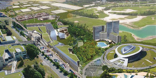
Urban planners are burning the midnight oil to draw Kenya’s future capital. From the look of things, the city will be grand in every sense of the word. Photo/GRAPHICS
Twenty-thirty has become a sort of catch phrase in Kenya, thanks to Vision 2030, a government development blueprint aimed at transforming the country into a middle-level economy in less than 20 years.
By 2030, Kenya hopes to be where eastern economic tigers like Singapore are today — economically, socially, and politically. Never mind that at independence, over 40 years ago, Singapore and Kenya were almost at par economically.
But that is not all. Come 2030, another marvel awaits Kenyans, thanks to the power and ingenuity of urban planning and design.


For the first time in history, the country — and indeed much of the continent — will have a world-class city or metropolis rivalling the world’s best, like New York, London, and Tokyo.
According to the Draft Spatial Plan for Nairobi Metropolitan Region, world-class living standards — good infrastructure, affordable housing for all, effective transportation, effective governance, secure neighbourhoods, and a booming economy — await residents under the jurisdiction of the City Council of Nairobi and 14 other local authorities that make up the 32,000 square kilometre Nairobi Metropolitan Region.
“The Nairobi Metropolitan Region Draft Spatial Plan is a metro-wide planning concept that not only interprets the Nairobi Metro 2030 strategy but also articulates the 15 local authorities’ uniqueness while remaining functionally interdependent,” says Mr Peter Kibinda, director of Metropolitan Planning and Environment in the Ministry of Nairobi Metropolitan Development.
The document, which was validated by stakeholders at a workshop in Nairobi early this month, has been forwarded to the Ministry of Nairobi Metropolitan Development for approval.
Under the new geopolitical system of the country, the Nairobi Metropolitan Region comprises four counties — Nairobi, Kiambu, Machakos, and Kajiado — with a total population of 6.7 million, according to the 2009 national population census.
Mr Kibinda says that the spatial plan shall determine how the Nairobi Metropolitan Region will develop over the next 22 years (although the target of realising a world-class African metropolis is 2030).
“It is expected to provide outstanding design and spatial solutions that take into account local conditions, location of different functions, facilities, and amenities of the area,” he says.
The spatial plan takes a critical look at the demography, economy, settlement pattern, transport system, physical infrastructure (water supply, sewerage and sanitation, solid waste management, and power), social infrastructure (educational, health and recreational facilities), security and safety, the housing situation, the environment, as well as urban design and regional landscape.
A major proposal by the spatial plan is the creation of six new towns in three of the counties, aimed at decongesting the existing ones.
The document describes these new towns as “the instruments for a balanced regional development with a desirable pattern of population distribution”.
“They are self-contained cities promoting economic development,” it says, noting that the six new towns, two in each county, would decongest the present Nairobi City.
The proposed new towns are Aerotropolis (near Thika Municipality, north of Garissa Road between the proposed regional orbital and the Great Eastern By-pass extension to Thika) and Knowledge-cum-Health City (north of Limuru Road near Ruaka) in Kiambu County, Cyber City (at the junction of the Greater Eastern By-pass and Kangundo Road) and Sports City (at the junction of Mombasa Road and the regional orbital) in Machakos County, Transport New Town (near the transport hub between Kajiado and Konza) and Amboseli New Town (adjacent to the Amboseli National Park) in Kajiado County.
According to the plan, the “vision statement” for the new towns will be “self-sustaining, eco-friendly, compact cities, making Nairobi Metropolitan Region a world-class metropolis.”
The new towns are planned to be in such a way that public transport leads urban structure with a hierarchy of open green systems including hillocks, water bodies, and urban forestry.
The document states that the new towns shall be infrastructure-led cities, where high quality urban services such as public transport, telecommunication and IT connectivity, water supply, sewerage and waste water recycling, power, and solid waste management shall be provided.
The new towns, the document goes on to state, will be developed on an area of 2,000 hectares each, with a gross density of 50 persons per hectare by 2030.
This means that a total of 12,000 hectares of land will be brought under urban development for the establishment of the proposed new towns, which are expected to comprise eight residential sectors having a population of 12,000 to 14,000 each.
The internal road network within the new towns will intersect at T-junctions with pedestrian-cum-non-motorised paths separated from the roads by green areas.
The street network will lead to major amenities such as retail centres, shops, schools, parks, and community facilities.
The towns will boast high speed rail connectivity between them and Nairobi City, as well as other major regional urban centres.
There will be high density developments along public transit corridors and areas adjoining the towns. Curiously, it has also been proposed that each of the towns will host an airport.
Another significant recommendation in the plan is that the urban design and regional landscape of Nairobi should be changed “to give a collective identity to the Nairobi Metropolitan Region, making it a sustainable-cum-competitive city region”.
To achieve this, the plan recommends the establishment of a new capital complex to give a collective identity to the region by virtue of its function, location, planning, and design.
Already, four sites — near State House, at Wilson Airport (with the backdrop of the Nairobi National Park), at the junction of Limuru Road and Kiambu Road (with the backdrop of Karura Forest), and outside Nairobi City — have been proposed for the project.
The selection of the capital complex site will be done by a committee to be constituted and comprising eminent professionals, artists, and the public.
A number of transit-oriented developments have also been proposed to create walkable communities, that is, easily reachable from major transit lines. A distance of 0.8 metres is proposed.
It will be mandatory for transit infrastructure, public space, and buildings to be of “human scale and enhance the experience of transit users, residents, and visitors”.
Transit architecture, public spaces, private development, and transportation functions will be integrated into a cohesive, distinctive urban place.
The settlement pattern in the towns will also form a major component of realising the dream of having a world-class metropolis.
Currently, there are about 620 rural settlements dispersed throughout the Nairobi Metropolitan Region.
There are also 23 urban centres in the region, the smallest being Kathiani in Machakos County with a total population of 3,365.
Kajiado County has the highest number of urban centres (10) with the lowest urban population — 5.7 per cent of urban population to the total population.
The envisaged metropolis will apply five levels of settlement:
Level 1 Regional Centre (Nairobi). It will have the highest order of economic and social infrastructure, with specialised world -class services and facilities. It will, for example, have specialised medical facilities and will also host a number of universities. It will also have the highest administrative functions.
Level 2 Sub-Regional Centres. They will have administrative functions/county headquarters, major commercial centre, degree level and technical training centres, intermediate hospitals, and a sports centre. The proposed settlements are Thika, Kikuyu, Kiambu, Machakos, Tala/Kangundo, and Kajiado.
Level 3 Priority Towns. These are new towns to be developed with the main aim of decongesting Nairobi. They will provide support for the Level 1 and 2 centres. They will have industrial services, police stations, and social/recreational centres.
Level 4 Growth Centre. They will be intermediary towns for promoting rural development and will be useful in achieving a balanced distribution of urban population. They will also provide linkages between smaller towns and the sub-regional centres. They will include Limuru, Karuri, Juja, Mavoko, Kitengela, and Loitokitok.
Level 5 Basic Village. These will be all other remaining rural settlements within the Nairobi Metropolitan Region.
It is important to note that other than the functions and characteristics stated above, the high level centres will also serve the functions of the lower level centres.
The core Nairobi area has been divided into eight divisions based on parliamentary constituency.
The spatial development pattern of Nairobi has been conceptualised as a multi-nuclei structure which has two alternate possibilities — uniform or non-uniform pattern
Of the eight divisions, the central business district (CBD) is proposed to service the three divisions of Makadara, Kamukunji, and Starehe.
The other centres are Langata, Dagoretti, Westlands (near Kenya Soil Survey), Kasarani, Embakasi, and Airport.
“However, Nairobi is the city which urgently needs a Master Plan (Land Use Plan),” notes the plan.
Well, 20 years might seem like a long time, but the journey to create a world-class metropolis that is expected to improve the quality of life for residents and create more business opportunities for investors has begun.
And, oh yes, a new world-class African metropolis lingers on the horizon.