Goodbye to causeway as modern, fly-over bridge takes shape
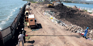
Construction work on the bridge to replace the Mbita Causeway in progress. PHOTO | TOM OTIENO | NATION MEDIA GROUP

What you need to know:
- According to Mr Obadha, who was at the forefront of the battle to have the causeway demolished, the structure was a political statement that did not take into consideration the environmental impact.
- According to the fisheries expert, there were more than 400 types of fish of high commercial value in Lake Victoria in the 1960s, but this number has been considerably reduced, with the Nile Perch, tilapia, mudfish and dagaa (omena) being the more common ones today.
- The bridge will be 160 metres tall, with a 70-metre carriage width for vehicles, and two metres for pedestrians. The vehicles and pedestrians will use the upper side of the bridge while the larger boats will use the lower side.
One evening in December 1973, Mr Harrison Odhiambo Opiyo caught the last boat from Mbita mainland heading for his home in Rusinga Island.
Unfortunately, he did not make it home because the boat capsized in Lake Victoria.
His daughter, Mbita MP Millie Odhiambo-Mabona, painfully recalled the events of that evening during a recent telephone interview with DN2.


“It was one of the saddest moments in my life,” says the 47-year-old, who was only four when her father died.
She later learnt that her father, who was going back home to join them that fateful evening, wanted to run for the Mbita parliamentary seat in the 1974 elections.
“Unfortunately he died a year before the elections, leaving my mother with six children to fend for,” the Mbita MP recalls.
When Mr Opiyo, a former member of the Nyanza Regional Assembly died, his daugher recalled, her mother, Damaris Odhiambo, was expecting.
“She got twins and the family grew to eight,” says the fourth born,” adding that she did not have any memories of her father because she was very young when he died.
Many lives had been lost in the small stretch of waters separating Rusinga Island from the Mbita mainland.
OLD FERRY
This was despite the availability of the old, manual ferry that was introduced to ease transport between Rusinga Island and the Mbita mainland, where most social amenities such as hospitals, schools, churches and markets were to be found.
Then, in 1982, a car belonging to former Mbita MP Alphonce Okuku, a brother of independence hero Tom Mboya, fell off the ferry and plunged into Lake Victoria. Luckily, the driver managed to get out.
“It took several months to retrieve the vehicle,” recalled 47-year-old businessman Okuku Miregi.
Mr Miregi said he attended Millie’s father’s funeral as a 4-year-old child.
It is because of the risky nature of water transport in the area that local leaders started asking the government to seek ways of improving transport between the islands in Lake Victoria and the mainland to curb the frequent tragedies associated with poor workmanship.
Their cry intensified after the incident involving Mr Okuku’s vehicle, with some pushing for the construction of a causeway between Rusinga Island and the Mbita mainland.
Their efforts bore fruit when a causeway joining Rusinga to the mainland was built in 1983 by blocking a section of the lake. A causeway is an elevated road or railway, usually across a broad body of water or wetland.
Even though the 200-metre structure seemed to have solved the problem, it turned out to be a double-edged sword.
“The causeway was built during a period of intense political activity, so no environmental assessment was conducted. Besides, the National Environment Management Authtority (Nema) had not been constituted to assess the possible impact of the channel,” said Mr Miregi.
DEMOLISH CAUSEWAY
But two decades later, environmentalists and marine experts began calling for the demolition of the causeway, saying it had led to the deterioration of the quality of the water, which had high concentrations of industrial waste and pollutants.
In 2012, Nema — it was formed on July 1, 2002 — called for the demolition of the causeway.
“Our stand is to have the causeway demolished and replaced with a trade-off system, where an environmentally acceptable alternative link is provided to sustain the socio-economic activities between the island and the mainland,” the authority director of compliance and enforcement, Mr Zephania Ouma, said.
He pointed out that the causeway, which was built using rock and earth filling, had permanently blocked a secondary connection between the Rusinga channel and the offshore waters of Lake Victoria.
He added that the lake’s cleansing capacity had been reduced because of lack of flushing and exchange of water between the two shores. This had also prevented the migration of fish and thereby, interfered with breeding patterns.
Pollutants had also affected fish breeding and resulted in a gradual fall in catches over the years.
“The Gulf side (Kisumu and Siaya waters), which covers 100km of the lake, was cut off from the main lake following the construction of the causeway. This interfered with the flow of water,” Michael Obadha, the assistant director of fisheries in charge of Lake Victoria, told DN2.
He added that river fish no longer bred in the area because of the poor quality of the water.
ENVIRONMENTAL IMPACT
Homa Bay County has the largest portion of Lake Victoria in Kenya, and therefore, also leads in fishing.
According to Mr Obadha, who was at the forefront of the battle to have the causeway demolished, the structure was a political statement that did not take into consideration the environmental impact.
“If you look at the causeway, you will realise that it blocked the free movement of fish from the Tanzanian side of the lake to Winam Gulf. This causeway was a major ecological disaster as it further blocked the migration route for fish,” he said.
This resulted in the depletion of commercial fish stocks of species such as the Nile Perch and tilapia.
In addition, many fish species such as tilapia and Nile Perch would move from deeper waters to shallow waters to breed and the young ones would also mature in shallow waters before moving to deeper waters.
In Kenya, 60 per cent of Lake Victoria has been gazetted as a breeding zone for fish, but the area around Winam Gulf does not favour breeding because fish eggs need light.
The principal fisheries officer in charge of riverine waters, Mr Robert Wanyama, says fish deaths have been high, especially of Nile Perch, since the species requires a lot of oxygen and clear water to survive.
He adds that “Riverine species on the Tanzanian side have disappeared because of no outlet from their breeding sites.”
“All the inputs from rivers in the catchment area are emptied into Lake Victoria, but are blocked at the causeway, forming algae deposits,” he says.
Today, the other side of the Mbita gulf has water with less silt but the water between Mbita and Kisumu is unfit for human consumption. The Mbita Gulf is served by rivers Awach Tende, Awach Kibwon, Sondu Miriu, Nyando, Nyamasaria and Kisat, among others.
Another disadvantage of the causeway was increased siltation, which led to the proliferation of the water hyacinth on the Winam Gulf side. This means that all the rivers flowing from Lake Victoria deposit silt and other components into the Lake.
“The main entrance of these rivers has been blocked, so now we have a backflow of water. This has polluted the water and made it unfit for human consumption, as well as unsafe for the various species of fish,” says Mr Obadha.
DEAD ECONOMY
According to the fisheries expert, there were more than 400 types of fish of high commercial value in Lake Victoria in the 1960s, but this number has been considerably reduced, with the Nile Perch, tilapia, mudfish and dagaa (omena) being the more common ones today.
Mr Obadha says that Migingo Island, which enjoys fresh water away from the Mbita Gulf, had gained value and prominence as large stocks of popular fish had migrated there, and it had become an excellent breeding ground for many species.
However, this might not necessarily be the case today.
The causeway is now being demolished and will be replaced with a steel bridge. This will be a major victory for ecologists and fisheries experts and a source of relief for residents, who are looking forward to its completion in December this year.
Mr Raphael Kabugu, the resident engineer contracted by the Kenya National Highway Authority, says the project will cost Sh600 million.
When DN2 visited the area a few months ago, engineers were erecting cofferdams, that is, watertight enclosures pumped dry to permit construction work below the waterline.
“We started demolishing the causeway in April 2013 and we expect to complete the bridge project by December 31, 2014,” says Mr Kabugu.
Once complete, the bridge, which is eight metres above the water level, will help restore water currents and allow the free movement of fish from the shallow grounds (breeding sites) to deeper waters bordering Tanzania and Uganda.
“The project, which is being undertaken by a Chinese contractor (China Jianghi International Construction Ltd), was supposed to be completed in August this year but after the residents appealed for further redesigning, we expect it to be complete in the next five months,” he says.
BRIDGE DESIGN
According to the engineer, the bridge was initially designed to be three metres above the water level but its height was increased to eight metres to enable it to accommodate larger boats and vehicles.
The bridge will be 160 metres tall, with a 70-metre carriage width for vehicles, and two metres for pedestrians. The vehicles and pedestrians will use the upper side of the bridge while the larger boats will use the lower side.
However, Mr Kabugu says, due to inadequate funds, the height of the bridge cannot be extended to accommodate ferries, which require a minimum of 13 metres above the water, while the bridge is only eight metres above the water.
Mr Kabugu says, first, they will install at least 42 piers (reinforcements) forthe bridge.
“We will then drill a further 15 to 20 metres to get to some solid ground under the water. After laying the foundation and the piers are put in place, a steel structure will be ssembled over the bridge,” says, Mr Kabugu, pointing at the ongoing works.
He says the steel structure will be imported and then assembled on site.
“We fear we might not meet the deadline because of the technical hitches we are experiencing,” he Mr Kabugu says, adding that the bridge will consist of two components, namely the super structure which consists of bridge beams and girders, and the reinforcement steel component.
He says the bridge, which can accommodate up to 54 tonnes, can last more than 70 years, as long as it is properly maintained.
Thrilled by the fact that the bridge will not only provide a better connection between Mbita mainland and Rusinga Island, but also allow free flow of water, local residents say there will be no more need for Kenya to fight over Migingo island with Uganda — Uganda can take the mostly rocky structure if it wants, they sneer — since fish from Uganda and Tanzania will be able to move freely aroudn the lake borders.
Philip Odero, who normally travels between the Rusinga and the mainland by boat, says the bridge will greatly reduce the distance.
“We will benefit from easier and cheaper transport,” he says.
Meanwhile, Mr Dancan Ajwang’, a fisherman, is thrilled that they will have enough fish stocks to sustain local production, as well as well as have some to send to other parts of the country.