Poor planning has only played up the city’s disadvantaged location
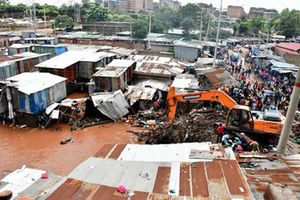
People try to push a vehicle that was abandoned by the owner in South C after roads was flooded following heavy downpour that left many Nairobians stranded on major roads. May 13, 2015. PHOTO | JEFF ANGOTE

What you need to know:
- Indeed, early travellers are reported to have remarked, “What a sight!” on reaching Nairobi. This was because Nairobi was incredibly windy during the dry season and extremely muddy during the wet season, since it was a basin comprising black cotton soil.
- The 1948 Master Plan for a colonial capital gave Nairobi its current shape. In this plan, a lot of land was set aside for green areas (riparian reserves), to help the city absorb rainwater. Huge open spaces such as Uhuru Park were a deliberate effort, which would act as the city’s sponges.
- Areas like South C did not experience floods until recently because they had considerable open spaces that absorbed rainwater. However, with increased development, the amount of space left to absorb excess water has been reduced considerably, hence the heavy flooding.
Burst sewer systems. Gridlocks kilometres long. Frequent power outages. Dry taps for weeks. Badly done roads that turn into lakes when it rains. Soaring cost of living.
Welcome to Nairobi, the nation’s capital, where South C estate turns into South “Sea” estate after a night of heavy rain. Where residents spend hours in traffic and get home at 4 am – to a flooded house.
Life in the city is hard enough, but when it rains heavily, Nairobi becomes a nightmare.


For the last month, Nairobians have borne the brunt of, and experienced first-hand, the effect of an overwhelmed, poorly planned city.
The recent floods not only destroyed property, but also traumatised children on their way home from school when their school bus almost tipped over in raging flood waters.
What happened to the Nairobi of the Eighties, when systems actually worked and floods were unheard of? What happened to Nairobi — the place of cool waters (as the Maasai named it) — that made it a death trap when it rains?
A look at its history provides some answers. A little-known fact is that Nairobi was never meant to be a town, let alone a city. When the colonialists looked at Nairobi, all they saw was flat marshland that became a “sea of mud” when it rained.
VAST MARSHLAND
But during the construction of the Kenya-Uganda railway, it was decided in 1899 that a railway station be built in Nairobi. It was felt that, since Nairobi was on a plain, it would make a perfect station, and the engineers working on the railway line could build a camp there. There were the added attractions of good, “cool” water and wildlife.
After the camp was established, Indian traders followed the engineers to sell them food and other supplies. In fact, historical records show that the colonialists had no intention of urbanising Nairobi, since Machakos was already serving as the capital of the interior, complete with a commissioner, Mr John Ainsworth, who was appointed by the Imperial British East Africa Company (IBEAC).
However, the railway did not pass through Machakos, thanks to the bad blood between Mr Ainsworth the engineers, so they connived to circumvent it. After the engineers had pitched tent in Nairobi, the IBEAC became bankrupt, so Mr Ainsworth was relocated to Nairobi.
But upon his arrival, all he saw was vast, flat marshland. Indeed, early travellers are reported to have remarked, “What a sight!” on reaching Nairobi.
This was because Nairobi was incredibly windy during the dry season and extremely muddy during the wet season, since it was a basin comprising black cotton soil.
In 1901, the plague struck in Nairobi, and there was great concern about the town’s e a large population. So it was recommended that the Nairobi Bazaar, where the Indians had set up their businesses, be burnt or relocated.
A health officer called Dr H.W. MacDonald wrote to London, seeking the colonial government’s intervention; he pointed out Nairobi’s unsuitable location and warned that it would be a nightmare if turned into a city. He further suggested that it be left as a simple train station and stopover.
Then, when a second plague struck in 1904, Mr Charles Elliot, the sub-commissioner for Eastern Africa, wrote to Mr Winston Churchill, then undersecretary for colonies, expressing concern about Nairobi’s drainage system (or lack, thereof).
Mr Churchill set up a health commission known as the Bransby William Commission, which noted that Nairobi could only survive with proper drainage.
The recommendation was, however, never implemented. The drainage crisis was attributed to the Indians’ system of disposing of human waste, which was said to attract lots of rats.
This reduced the drainage crisis to a war between the Indian and Europeans, and it remained unsolved because the Europeans did not want to be seen to be biased against the Indians, given that part of Ainsworth’s assignment in Nairobi was to make it hospitable to the traders.
Thereafter, Nairobi began flourishing, with hotels such as the Norfolk being built in 1904 to cater for new arrivals, including railway engineers, travellers, businessmen and traders.
MASTER PLAN
Big game hunters and anyone in transit to any part of East Africa would make a stopover in Nairobi because it was famed for its great hotels. Banks also began operating, followed by entrepreneurs. What started as a small railway station soon grew into a vibrant town – but with a serious drainage problem.
The 1948 Master Plan for a colonial capital gave Nairobi its current shape. In this plan, a lot of land was set aside for green areas (riparian reserves), to help the city absorb rainwater. Huge open spaces such as Uhuru Park were a deliberate effort, which would act as the city’s sponges.

People try to push a vehicle that was abandoned by the owner in South C after roads was flooded following heavy downpour on Tuesday night that left many Nairobians stranded on major roads. May 13, 2015. PHOTO | JEFF ANGOTE
Areas like South C did not experience floods until recently because they had considerable open spaces that absorbed rainwater. However, with increased development, the amount of space left to absorb excess water has been reduced considerably, hence the heavy flooding.
Lawrence Esho, the chairman of the Department of Spatial Planning and Design at the Technical University of Kenya, attributes the heavy flooding to the fact that there is no elaborate plan to map out the drainage in South C, unlike in the city centre, where the drainage has been well mapped out.
“The people who built the original South C paid attention to the drainage system. But when you build a city piecemeal, and by different people with no government input, the planning is done piecemeal and the drainage component is not done very well,” he says, adding that the drains in South C are not only too small, but also poorly designed.
Good drainage, not tarmac roads, is what Nairobi needs he says, adding that road engineers pay little attention to drainage, an oversight that will eventually cost Nairobians a lot more.
“If you look at all the new roads being constructed in the city, they start by paving the road but they don’t pay too much attention to the drainage. And when they build a drain, there is no way for the water to flow from the road to the drain,” he adds.
Remarkably, neighbouring Langata does not experience floods because it slopes, so the rainwater drains into River Mutuini. Nor do Wilson Airport and the Nairobi National Park because they have enough open spaces to absorb excess water.
The flooding in South C, Nairobi West, and Mbagathi areas can be solved through planning that takes into consideration their geography to provide for natural systems of storm water drainage.
“However, in the absence of open-air spaces to absorb the storm water, you have to have a lot of engineering solutions. You need huge, man-made drains to discharge the water,” says Mr Esho.
He believes that critical infrastructure decisions are not being made, and inadequate funds set aside for drainage.
“I feel we have failed to find an engineering solution to drainage because cities grow; ours is not even something to cry about. We still have huge streets and huge opportunities to expand the drains but we are not doing it,” he says.
Nairobi County Executive Member for Lands, Housing and Physical Planning Tom Odongo says that poor systems of waste management interfere with the optimal performance of the infrastructure currently in place. In most cases, the storm water is accompanied by solid waste, which hampers the drainage systems’ ability to drain the water.
INTEGRATED APPROACH
The river courses have also been changed, with some canalisation having been done to divert their waters. However, the canalisation has not been properly done, such that when it rains heavily, the water forces its way via its natural course.
“We have different agencies approving different things. There is multiplicity of actors in the urban space, so you find that one agency has approved the canalisation and diverting of a river without consulting the other,” says Mr Odongo.
That roads in the country are built by different entities — the Kenya Urban Roads Authority, the Kenya National Highways Authority, the Kenya Rural Roads Authority, and Nairobi County — validates his statement.
“But when you make roads, you must also do the drainage. The road agencies increase the road space and, therefore, the amount of runoff but they are only concerned about getting it off the road. Where it goes is not their business. It means that somebody has to pick it up from where they left off,” says Mr Odongo.
To develop a functioning and adequate drainage system, Odongo suggests an integrated approach, where the agencies consult rather than act unilaterally.
As the population of Nairobi increases, so will the runoff that needs to be channelled into the drainage systems.
The inadequate funding is reflected in the poor storm water drainage, alongside the crazy traffic snarl-ups.

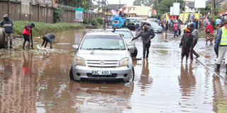
Kenya Power Nairobi West Substation, along Mombasa road that was submerged in flood water following a heavy downpour on May 13, 2015. PHOTO | JEFF ANGOTE
UNIQUE TOPOGRAPHY
Experts agree that the city’s current flooding crisis has everything to do Nairobi’s topography, history, drainage and planning glitches that make the city a disaster waiting to happen.
Nairobi has a unique topography because it is at the point where the landscape changes from highlands to lowlands, making it the lowest end of the Aberdares slope. So all the water from the hilly areas drains into the flat, Nairobi basin. It is no wonder, then, that areas like Embakasi are swampy; in fact, Embakasi is the Maa word for “swamp”.
One master plan after another
THE 1898 MASTERPLAN was the first plan that laid out Nairobi as a town, complete with a railway depot, with the main feature being the railway station and railway line. It is said that this plan has a striking resemblance to the town layout of today’s Nairobi Central Business District.
The 1926 Plan for a settler capital expanded the city by 77km to accommodate the growing population. It capitalised on the city’s strategic position as a vibrant hub of the Kenya railway line.
The second Master Plan was drawn up in 1948, the main aim being to make Nairobi an attractive industrial town.
In 1973, the government, World Bank and the UN formulated a metropolitan growth strategy for the city. The 1973 Master Plan, which expired in 2000, was used until 2013, when the county government launched the Sh300 million Nairobi Integrated Urban Development Plan (NIUPLAN) funded by the Japan International Co-operation Agency. It was rolled out in April and covers the next 17 years.
The NIUPLAN will integrate the infrastructural plans in all the other master plans for the city and its surroundings. It provides for water infrastructure, riparian way leaves and riverine drainage as well as waste water disposal and storm water drainage.
“For us to move this city to the next level and become a competitive urban centre, we must operate within an integrated, comprehensive and holistic template. All of us can have our own investment plan, but we must read from the same document,” says Mr Odongo.
Nairobi’s master plans have, throughout the years, always catered for drainage, and specifically storm water drainage, but the problem has been implementation.
“As a country we have been very poor at implementation. Planning has never been our problem. Our plans have failed at the implementation level. It is not that people do not understand the issue, it is purely about implementation,” says Mr Odongo.