Mfangano, an island looking for tourists
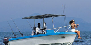
A sailing boat at Mfangano Island. The island lies at the mouth of Lake Victoria’s Winam Gulf, just east of the border with Uganda. PHOTO/FILE

What you need to know:
- Despite the long ferry journey, the island is easily recognisable from the mainland by the imposing green-clad cliffs of Mount Kwitutu, which rises 1,694m from the island’s centre.
- One of the only other options for accommodation, though at the complete opposite end of the scale price-wise, is the much more up-market Governors’ Camp.
- Its remote location, however, has meant that I was among only 50 people to have visited the site this year.
My dad likes to show off that he has visited every major town in Kenya.
Not only is this a massive claim, but I could also easily ask what constitutes his definition of a “major town”.
Either way, he has undoubtedly travelled a lot, and I suppose the proof is in over two decades’ worth of Going Places articles.


Though I too like to think that I am well-travelled in Kenya, I had never been to Kisumu and its neighbouring towns on the eastern shores of Lake Victoria. That was until a few weeks ago. The island lies at the mouth of Lake Victoria’s Winam Gulf, just east of the border with Uganda.
I was there on an assignment to monitor and document the progress of the Lake Victoria Rights Programme, which is involved with awareness creation and advocacy around the major social and economic issues affecting the fishing communities of Lake Victoria.
The primary focus of the programme is on sexual and reproductive health rights; the prevalence of HIV and Aids on the island is among the highest in the region.
BIGGEST TILAPIA EVER!
The trip also coincided with the commemoration of World Aids Day, which was being held on the island for the first time in its history.
Before embarking on the four-hour journey to Mfangano, we had just enough time to have lunch in Kisumu at one of the many food joints that line the shore of the lake near the town centre.
We settled for one of the “Car Wash Fried Fish Kiosks” and tucked into the biggest Tilapia I had ever seen. The whole scene reminded me of Labadi Beach in Accra, Ghana, with its popular beach-front local fish restaurants.
There are two main ways to get to Mfangano Island from Kisumu. The first is to drive down south to Luanda-Kotieno, where you can take a 30- minute ferry to Mbita.
Here you take another ferry for an hour and 45 minutes, which stops off at Takawiri Island before it reaches Mfangano. The second option is to drive for two hours straight to Mbita and take the ferry from there.
Despite the long ferry journey, the island is easily recognisable from the mainland by the imposing green-clad cliffs of Mount Kwitutu, which rises 1,694m from the island’s centre.
Although the elevation means that most of the settlements are on the outskirts, by the lake, a number of small-scale farmers live permanently on the island’s undulating slopes.
We didn’t have the time to attempt the hour-and-a-half trek to the summit, but I imagine the views of the lake and the Gwasi Hills on the mainland are spectacular.
We were staying at the Mfangano Island Beach Club, not far from Sena — the dusty town on the eastern side of the island where the Mbita ferry dropped us off.
CHARMING ESTABLISHMENT
The club has been open for only a few months and it was clearly a work in progress.
Apart from the kitchen and an adjacent space for the generator, the only other physical structure is a banda with two rooms and a thatched roof. There are also two large tents and plenty of space for people to pitch their own.
According to Ruth Akinyi, who runs the place, they can currently only accommodate up to 10 people, at Sh1,500 per person per night, bed and breakfast.
In a way, the lack of development adds to its charm: meals are served in the open under a small thicket of trees, only a stone’s throw away from the lake.
One of the only other options for accommodation, though at the complete opposite end of the scale price-wise, is the much more up-market Governors’ Camp.
The island even has an airstrip, which is mainly used for the guests of the Camp. Whereas Governors’ is all about seclusion (its website describes the camp as “lost to the world”), the Mfangano Beach Club is far less detached from the community.
On the last day of our visit we were treated to a boat trip around the island – the highlight of which was a tour of the well hidden, but very interesting Mawanga rock art site.
According to our guide, the site is around 4,000 years old, and consists of a series of white and red concentric circles on the wall of a large cave.
The cave is sacred to the Wasamo, who are the rainmakers of the Abasuba community.
The island is home to Kenya’s largest population of Suba people – migrants from the old Buganda Kingdom of Uganda.
The red and white circles were used for specific rainmaking rituals. The red circles, representing the moon, were drawn in times of rain, and the white circles, representing the sun, were drawn in times of drought.
The site was launched by Trust Africa Rock Art (TARA) in 2005, and was recently improved with funding from the EU.
Its remote location, however, has meant that I was among only 50 people to have visited the site this year.