Bridges of Tsavo
What you need to know:
- Rupi Mangat explores fascinating relics of WW1 in Tsavo West
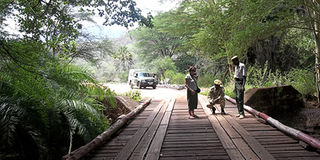
Under a searing midday sun in a remote part of Tsavo West National Park, we’re standing on a bridge that’s close to a century old. It is rarely used yet once it was once of utmost importance.
Few know that the area between Voi and Taveta was the scene of intense fighting during the early months of the First World War when Britain declared war against Germany on August 4, 1914.
Even though Africa had nothing to do with it, the following day, the British governor in British East Africa, Sir Henry Belfield, advertised that the protectorate was also at war, pitting BEA against GEA – acronyms for British and German East Africa, ie present day Kenya and Tanzania.


The simple-structured bridge that we stand on is built over the raging Tsavo River in a remote area called Rhodesia – named after Cecil Rhodes (5 July 1853 – 26 March 1902).
Rhodes was an English-born South African businessman and the founder of the diamond company De Beers and the state of Rhodesia (present-day Zambia and Zimbabwe).
Tall order
Army trucks and soldiers in combat must have crossed over the bridge watched by beady-eyed crocodiles waiting for an unfortunate victim to fall in. At that time there was no Tsavo West National Park, as we call the area today.
The tides of time have passed and all that is left are the relics – disused and forgotten.
“2014 will mark the centenary of the start of WW1,” states Muraya Githinji, the Kenya Wildlife Service tourism warden in Tsavo West. “We are searching for sites from that era to attract war enthusiasts and interested visitors to the park.”
In a park that is a 7,065-square-kilometre mosaic of dense thorn scrub, lava, grass plains, impenetrable doum palm forest, raging rivers during the wet season and volcanic hills under the shadow of Kilimanjaro, it is a tall order.
But we are in the company of Karanja Edward Njuguna, the warden-in-charge of the rhinos. On his daily patrols in search of his charges, the soft-spoken warden conducts an aerial survey and in the process has spotted bridges that point to relics of the war.
“We suspect this is Rhodesia Bridge (now Tsavo bridge) because according to the old maps, the bridge is by the base of the observation hill,” Njuguna says, pointing to the acacia-scattered red hill that is a trademark of the red soils of Tsavo. “At the pinnacle is the ruin of a British lookout post.”
We walk across the original planks and the iron framework and climb under the. The pillars supporting it would take five men to encircle them.
“This bridge will last another hundred years,” Muraya comments in awe.
Njuguna has spotted another from the air; it straddles Kitani River by a thick grove of doum palms. We scramble down the banks of a partially dry riverbed and carefully walk the length of a gigantic tree trunk that fell on the bridge. It is a drawbridge and is not supported by pillars like the first one.
“Drawbridges are designed this way to ensure that access to one side is controlled,” Muraya says. “Whoever designed this bridge wanted to control the access from one side of the river. The bridge faces the southern part from where the enemy (ie the German Schutztruppe) would approach.”
At the end of the bridge are two hinged iron ramps which could be drawn up or down. Playfully, Muraya pulls one and to our surprise, it is still in working condition. Looking closely, Muraya and Karanja realise that the design of the two bridges is very different.
The downriver bridge – ie the Tsavo bridge – seems to have been assembled on site with lots of bolts and nuts whereas the drawbridge is welded to the frame. They are still trying to figure out why.
All the bolts on the bridges are original – a little rusty but their more than 10 inches length connecting the wooden planks to the metal frame.
Lion census
A few metres away, the white waters of Mzima River flow into Kitani River.
“Mzima Springs is seven kilometres from here,” Karanja tells us.
The two rivers then merge into Tsavo River and flow into Tsavo East, which courses the plains and flows into the Galana and finally ends up in the Indian Ocean.
While the day is busy with the search for the bridges of Tsavo, we leave the evenings for the lions and the rhinos. In the late 1800s, Tsavo was terrorised by man-eaters (lions) that had developed a taste for human flesh – mostly the Indian rail workers. Today, few lions remain.
Late in the night, we sit in silence with the research team playing sound recordings of buffaloes and hyaenas to attract the lions.
It’s the first lion census in Tsavo West and the one-week exercise will give an estimate of the number of lions in the park.
On reaching Ngulia Lodge, our abode for the night, we miss the leopard at the bait hung for it every evening and have to contend with the hyenas.