List of 13 flooding prone roads to avoid in Nairobi
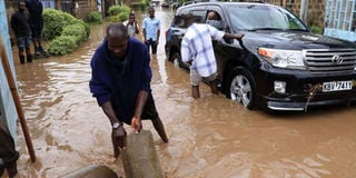
A motorists navigates through flooded roads at a Nairobi estate in South C on April 1, 2016 after a night downpour. The National Transport and Safety Authority on May 1, 2016 released a list of thirteen roads to avoid in the city. PHOTO | JEFF ANGOTE | NATION MEDIA GROUP

What you need to know:
- Nairobi has also recorded the highest number of casualties after 17 people confirmed dead.
- Fourteen people have been confirmed dead from the collapsed building in Huruma.
The National Transport and Safety Authority (NTSA) on Sunday released a list of 13 roads motorists should avoid during downpour due to risks of flooding.
They include Langa’ta Road especially around T-Mall, Muhoho/ Popo Road junction, Muhoho Road at Ngong River crossing, Baricho Road, Lusaka Road, Jogoo Road near Makadara Law Courts, James Gichuru Road at Olenguruone junction near Convent Drive junction, Marcus Gurvey/Chania Avenue junction, Kipevu and Ushirika Road junction, and Jakaya Kikwete Road at the outlet of main drainage from Department of Defence and Lenana Road near the DoD gate.
Friday, three people died when a perimeter wall on Lenana Road near the DoD gate collapsed falling on pedestrians who were shielding themselves from the torrential rain that has been pounding the City this week.


According to the Meteorology Department, Nairobi has so far received the highest amount of rainfall and the highest number of casualties after 14 people were confirmed dead Sunday from a collapsed building in Huruma, bring the death toll to 17.