Nature and poor planning the bane of Narok
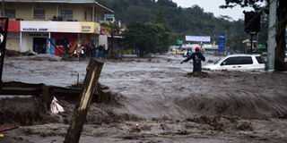
Flash floods that occurred in the wake of heavy rains in Narok County. Narok town has suffered deadly flash floods each time it has rained heavily since 1992. FILE PHOTO | GEORGE SAYAGIE | NATION MEDIA GROUP

What you need to know:
The chairman of the Narok Council of Elders, Kasaine ole Esho, said Maasai forefathers set the location for the town in a valley to protest a white settler’s idea.
Environmentalists said Narok floods even with normal rains because of excess surface water runoff due to deforestation and land degradation upstream.
According to county government records, Narok town covers 692 square km and is poorly planned.
Narok town has suffered deadly flash floods each time it has rained heavily since 1992. And the cost has been expensive.
More than 50 people have been killed and millions of shillings in property lost to nature’s fury.
The often dusty town, the gateway to the world-famous Maasai Mara Game Reserve, sits on a bowl-like surface.


The chairman of the Narok Council of Elders, Kasaine ole Esho, said Maasai forefathers set the location for the town in a valley to protest a white settler’s idea.
“Our forefathers were opposed to setting up a town, and so they gave away this location hoping the town built by the settlers would easily be swept away by water since it’s in a valley,” Mr Esho said.
TOWN BETWEEN TWO STREAMS
He said the town was set between two streams that pour their water into the Enkare Narok River and, naturally, when it rained, the streams would flood, carrying water from the upper catchments of Olopito and this could not be stopped. This is a fact the elders knew very well.
Environmentalists said Narok floods even with normal rains because of excess surface water runoff due to deforestation and land degradation upstream.
Dan ole Sapit, a climate change advocate, said: “The general topography of Narok town is considered a recipe the upper catchment is restored, water conservation and harvesting and improving the forest cover at the Mau Forest, is carried out.”
POOR PLANNING
Narok Business Traders Association chairman David ole Sankok said poor drainage and perennial flooding have been destroying businesses and discouraging investment in the town that a World Bank report described as a high potential business area.
Mr Sankok lamented that the town lacked proper waste management and that development in it is uncoordinated.
Houses in the town do not meet the demand of an increasing population. This has led to the emergence of slums such as Majengo.
According to county government records, Narok town covers 692 square km and is poorly planned.
The town has 10 electoral wards and, in 2009, according to that year’s census, it had a population of 103,598.
The county government said it loses up to Sh5 million in parking fees monthly due to the poor planning as businesses lose Sh15 million every year to flooding.
“Poor planning has significant contributed to our inability to collect plot rates and parking fees leading to poor ineffective services,” said lands, trade and planning minister Allan Twala.
UNKNOWN DEVELOPERS
He cited uncontrolled development in the town as a hindrance to revenue collection since some developers are unknown.
The drainage system has collapsed and politicians protest a plan to replan the town and relocate a part of the town.
According to Matrix Development Consultants, a firm contracted to re-plan and restructure Narok town, this would boost the town’s potential as a business hub.
The project will cover 74 square kilometres.
The county government has said it will complete five flood check dams and 20 water pans in the outskirts of Narok town to control water from flowing into the town.
Governor Samuel Tunai announced that existing flood paths through the town are being widened and deepened to further ease water flow.
An inter-agency committee under the Ewaso Ng’iro South Development Authority, the Water Resource Management Authority and the Ministry of Devolution and Planning is spearheading a plan to control flooding.