New underwater discoveries in Malaysian plane hunt
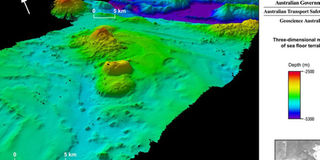
A handout image obtained from Geoscience Australia on September 27, 2014, shows the MH370 search area encompassing the seabed on and around Broken Ridge, an extensive linear, mountainous sea floor structure that once formed the margin between two geological plates. PHOTO | AFP

What you need to know:
- Australian authorities released the three-dimensional images on Friday, revealing for the first time details about the seafloor where efforts are being concentrated to find the jet, which is presumed to have crashed into the sea on March 8.
- The plane with 239 passengers was headed for Beijing.
SYDNEY, Saturday
Remnants of volcanoes, towering ridges and deep trenches have been discovered on the sea-bed of the southern Indian Ocean by experts mapping the underwater terrain as part of the search for missing Malaysian Airlines flight MH370.
Australian authorities released the three-dimensional images on Friday, revealing for the first time details about the seafloor where efforts are being concentrated to find the jet, which is presumed to have crashed into the sea on March 8.


The area in which the plane is thought to have gone down is remote and largely unexplored, and officials are conducting an intensive survey of the seabed before the underwater probe for the plane can begin.
“The recently acquired high-resolution bathymetry data has revealed many of these seabed features for the first time,” the Australian Transport Safety Bureau, the agency leading the search, said.
The plane with 239 passengers was headed for Beijing.