How GIS tech can be used to control locust menace

Ali Hasham demonstrates GIS technology solutions on his laptop. PHOTO | FAUSTINE NGILA | NATION MEDIA GROUP

What you need to know:
- The government can utilise real time geo location in tracking and tracing the spread of the locust invasion in the country.
- The challenge in taming these dangerous insects lies in the the government's inability to provide data about a new threat to food security, and this has subjected herders and farmers to traditional methods of control.
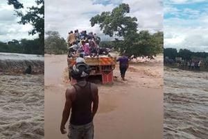
- In times of floods, mudslides, earthquakes, drought or famine, GIS can be used to identify most affected zones and recommend aid to those communities.
When he graduated from the Southern Alberta Institute of Technology in Calgary, Canada, in 2011, he flew back to Kenya armed with knowledge and skills to model solutions around Geographic Information Systems (GIS) for local problems.
While in Canada, Ali Hasham secured a job in the oil and gas industry, where he utilised the power of metadata analytics to create pipelines and well sites for Suncor Energy.
“It was here where I honed my skills in combining my GIS knowledge and Big Data to come up with relevant solutions to hurdles we face today,” he passionately tells the Nation.


Tenacious and resilient, his capacity to harness technology to find answers saw him work for several data mapping companies till 2017, when his initiative led him to personally contribute to bridging gaps in Kenya’s socio-economic development space.
SKILLS SHARPENED
Identifying challenges as opportunities, and partnering with structural engineers, he had become the most sought after expert in GIS research and analysis in Nairobi and its environs, till the call to become a market player came.
“I had numerous experiences, deriving 3D hydrological models from digital elevation models in dam construction in Northern Kenya. I also performed slope calculations and spatial analysis using soil data in road construction,” he narrates.
The 35 year-old kept broadening his knowledge base by developing digital maps and data repositories for researchers of urban planning in Nairobi’s slum areas.
“I sharpened my skills in locating smallholder farmers using geo mapping tools. That led me to create mapping and field data tools,” explains Hasham.
In February 2017, he founded his own GIS data analytics firm focusedon all sectors of the economy, and thus the name Kila Kazi Enterprises.
According to him, many challenges exist in the social and economic arena and their complexity requires use of data and sophisticated software to model solutions for human and animal benefit.
“When I registered Kila Kazi, my goal was to offer interactive web mapping solutions for clients, such as better insight, representation and analysis of data, but that has expanded to improved accessibility via mobile, desktop and enhanced sharing across teams,” he explains.
LOCUST INVASION
For the past two years, he has been building and managing data repositories for clients, enabling them to make better data driven insights and business decisions through data collection and analysis.
He reveals that he has another revenue stream, apart from selling data solutions to companies and government agencies.
“I also train and mentor corporate staff about business analysis using geospatial tools at various venues such as branches of commercial banks. The training has enabled them build better business models informed by this accurate data,” he says.
When this writer caught up with him for the interview, he demonstrated on his laptop how the government can utilise real time geo location in tracking and tracing the spread of the locust invasion in the country.
Using geographical and demographic data about every county in the country, GIS analysis must put into consideration data about the life span of a locust, the speed of migration, total number of locusts, eggs laid per day, land area destroyed per day and the direction of migration to control the menace that has wiped out green vegetation in Rift and Northern Kenya.
“Locusts can travel up to 130 kilometres a day while a swarm may contain up to 80 million locusts. That is data that is already available but we need more to effectively control the spread of the pests using GIS,” says Hasham, who now consults for Big Data firm Predictive Analytics.
KEYCHALLENGE
The challenge in taming these dangerous insects lies in the the government's inability to provide data about a new threat to food security, and this has subjected herders and farmers to traditional methods of control.
“If we had this data right now, I would be leading in monitoring their migration in real time and advising on the best ways to curb the destruction using the right pesticides and automated drones that don’t risk the lives of pilots,” he expounds.
It has been reported that swarms impair visibility when helicopters are used to spray them at close range, to the extent of breaking the windscreen and entering the copter with fury.
OTHER ISSUES
Hasham says this is not the only way GIS analytics can be deployed to help deal with disasters.
In times of floods, mudslides, earthquakes, drought or famine, GIS can be used to identify most affected zones and recommend aid to those communities.
The technology can be used in almost all spheres of human life and business where complicated and intense challenges are experiences, including providing intelligence about terrorists, thieves, rapists and other evil doers.
He mentions that he has been using it for market intelligence in sectors such as banking, insurance, retail, transport, land mapping, urban population planning and agriculture.
“It can also be used to control forest fires, eradicate poaching, monitor oil pipelines and electric cables, supervise irrigation schemes, oversee the distribution of dairy products, watch over property while analysing road safety,” he says.
Mr Ngila is a 4IR journalist at Nation Media Group. [email protected] @faustination