Nairobi residents paying price for land grabbed from raging rivers
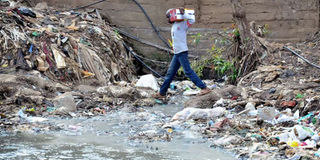
A young boy jumps over a pile of garbage dumped onto Nairobi River as it passes between two slums Mukuru Kwa Rueben and Kingstone located in Starehe Constituency on April 10, 2018. PHOTO| FRANCIS NDERITU
Warning, this plot is not for sale, but a private land. Trespassers will be prosecuted. Hakuna njia (No through way),” reads a sign erected on a four-acre piece of wetland in Mountain View Estate in Nairobi.
The land in question is under armed guard protection day and night, just in case the ominous sign doesn’t deter people who might show interest in it, and especially residents of Mountain View who have been trying to have it reclaimed and reverted to its status as a wetland.
The land is pretty prime, with developers constantly seeking to get it onto their portfolio. In March, a group came scouting, seeking to view the land which has changed hands three times, and every time, the buyers have not been able to develop it, perhaps because it is a wetland, the source of Rivers Thiboro, Waititi and Machagucha, which join Nairobi River downstream. It was allegedly acquired by the National Social Security Fund (NSSF) in a questionable manner, and subdivided and sold.

Shanties in Mukuru kwa Reuben, erected right next to the river, held up by concrete beams. Aside from building on the river bank, the residents also pollute the river with garbage and sewage, exposing themselves to health risks. PHOTO| FRANCIS NDERITU
Fifty-two-year-old Nancy Mbugua, a resident of Mountain View and manager of Mountain View Estate, has been at the forefront of fighting for this wetland, keeping at it for 10 years.
“We wrote to the Ministry of Lands to stop the sale, but our protests fell on deaf ears. Now I hear it has been bought by a Korean who wants to construct a hotel,” says Ms Mbugua, who is worried that the destruction of the ecosystem will affect residents downstream.
CONTESTED LAND
Directly opposite the contested land are shanties in Kangemi, built right on top of the rivers, but held up by wooden and concrete beams that raise the structures above the raging swollen waters.
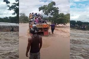
A similar scenario plays out in Mukuru kwa Reuben and Kingston, informal settlements south of Nairobi, where residents have encroached on river channels, filling up River Ngong that passes through the settlement with soil or constructing walls to block the river and create space to put up their structures.
“They poured soil to raise the ground to find space for construction, but when it rains, people lose their lives and there is a lot of destruction from the floods,” says Melvin Njoroge who runs a makeshift bridge connecting Kingstone and Mukuru kwa Reuben.
***
An investigation by the HealthyNation found these scenarios replicated from informal settlements to high-end estates across the city.

A building on Racecourse Road earmarked for demolition because it is built right on the banks of Nairobi River, in contravention of the law. PHOTO| FRANCIS NDERITU
No riparian land or wetland has been spared in the quest to fill any and every open space with a building. And nature being no respecter of persons, the residents have suffered the consequences, as the four main rivers passing through Nairobi – Ngong, Nairobi, Kirichwa and Mbagathi – surge, looking for a way through what were once river banks and river channels.
As swollen rivers try to find their way through or around buildings standing in their way (atop waterways and riparian reserves and wetlands), tens of people have died, thousands have watched angry waters destroying their properties and roads have been rendered impassable with resultant traffic jams, as heavy rains pound the city and leave a trail of destruction.
One such building is the imposing South End Mall just opposite T-Mall shopping Centre that stands atop Mutuini-Ngong River along Langata Road, and has been accused of obstructing the river leading to perennial flooding and destruction of property in Nairobi West, South C and Langata.
In May 2015, 11 people died downstream in Fuata Nyayo slums, when a wall collapsed following heavy flooding believed to have been caused by the obstruction of the river by the mall. In an interview with the Nation the same month, the owner then Bobasi Member of Parliament Stephen Manoti claimed that he had all the necessary approvals from City Hall and National Environmental and Management Authority (NEMA), despite the two later ordering for the demolition of the building. Manoti obtained a court order to stop the demolition. City Hall challenged the order in court in early 2017.
In April 2017, the then County Executive in Charge of Lands Christopher Khaemba said that City Hall was not going to approve occupation of the building. However, Nation can confirm that the building is occupied.
The matter has seen a sustained back and forth between authorities and the owners since construction commenced, with authorities maintaining that the building needs to be demolished because of the risks it poses to thousands of Nairobi residents. As the tussle continues, the rain continues to beat those who reside in the surrounding areas.
“All this boils down to corruption, if we consider the law strictly, the building was not supposed to be approved. It means that some officers were compromised. It is unfortunate when a few people hold millions of others at ransom. If the distance from a riparian reserve has not been conformed to, it is blocking the channel,” said Mr Henry Ochieng, the CEO of the Kenya Alliance of Resident Associations (KARA), in an interview with HealthyNation.

Shanties in Kangemi, which have been built right on or next to two rivers, leaving no space between them and the rivers as is required by law. PHOTO| FRANCIS NDERITU
The script is the same in other parts of the city from Lavington to Mukuru where rivers have been choked, quite literally, by buildings set up on riparian reserves, on river banks, wetlands and even right on top of rivers.
In March 2016, the Law Society of Kenya sought to stop development of a controversial piece of land along Njumbi Road in Lavington, originally gazetted as a wetland by NEMA and the Water Management Authority (WRMA). The construction went on, and as a result, residents in the area around Njumbi Road have felt the pinch of flooding during this rainy season.
During a recent KARA meeting, a representative from the Lavington residents Association decried the struggles residents face when it rains, and on cue, floods.
“The area is a riparian land. We want to know why these two wetlands cannot be reclaimed. The place floods completely, the road floods because there is a wall,” said the representative, who indicated that there were developments on the wetlands which obstruct river flow, leading to flooding.
In 2016, Nakumatt Ukay in Westlands was temporarily closed when floods washed through the supermarket, destroying property of undisclosed value. It was like a river had cut right through the building, which stands in an area where flooding is common.
Things don’t get any better in the outskirts of Nairobi with Green Park Estate along River Athi having faced the wrath of the second-largest river in Kenya in the form of devastating floods, when the river burst its banks.
Tom Chavangi the CEO of the National Lands Commission (NLC), which is tasked with managing public land on behalf of the national and county governments says that the developed riparian lands were grabbed.
“We have revoked licenses of developments on wetlands, but land grabbers and cartels are stronger than us,” he said during a Kenya Alliance of Resident Associations meeting in March.
OFFICIAL POSITION
However he said that there were no malls on Nairobi River and its tributaries. “There are no malls on top of Nairobi River, and there is none along the riparian reserves. What is possible is that they are on the temporary water storm pathways, and the solution to that is to make sure that the developers construct sufficient storm drains to drive out that water.
“Thika Super Highway is always flooded whenever it rains because of structures, poor planning hampers water draining, it has been obstructed on its natural channel,” said Chavangi.
“We are going to demolish all buildings on the reserves because they are death traps. We are going to clean these riparian reserves. We will plant trees to prevent soil erosion,” said Nairobi County Executive Officer in Charge of Urban Renewal, Housing and Building Services Peter Wachira Njuguna.
“All the people who have built on riparian reserves are land grabbers and we are going to demolish all those buildings,” he said, and pointed out the low- income areas where some people have constructed permanent structures are the most affected. “We are telling them that it is time to move out because they are endangering lives,” he said.

Nancy Mbugua who has been at the forefront of fighting for the preservation of a wetland in Mountain View Estate. PHOTO| FRANCIS NDERITU
“As a county, we are making sure that all the approvals that we give show the availability of sufficient storm drains so that we are able to drain that water out of the City,” added Mr Wachira.
However, a spot check by HealthyNation showed that some of the disputed developments have the rivers passing under them or have streams that were diverted.
The HealthyNation followed these rivers through Ngong,’ Lang’ata, Kibera, Globe Roundabout, Riverside, Country Bus, Majengo, Mukuru slums, Nairobi West, South B and South C, Kangemi, Mountain View, Loresho and the situation was the same. There is massive pollution, while numerous car wash points dot the river banks.
Satellite images not only reveal the extent of the encroachment of the rivers, but also the exact points where the channels have been obstructed by garbage.
These are Mukuru slums, Imara Daima, Viwandani, Pipeline (Quarry) Umoja, Kayole (Soweto) and Chokaa, where Ngong’ River seems clogged by huge mounds of garbage.
***
PERSISTENT PROBLEM
In May 2016, the Nairobi County Government announced that there were 2,000 plots of land in the hands developers that lay on riparian lands.
The county said that it had written to the Ministry of Land to revoke title deeds those pieces of land, to pave way for them to be reclaimed for restoration and reservation, and to pave way for the demolition of any buildings erected on them.
Riparian land is the land on the river bank of a river, that provides allowance for the river to swell and flow without obstruction during heavy rains, while wetlands are swamps and marshes that are intermittently covered with water, playing an important role in the ecosystem.