A tale of two rivers...and yet another go at restoration
A young man places his hands into the cold clean mountain water which flows from Ngong Forest as the main source of Nairobi River. PHOTO| FRANCIS NDERITU


The dust, and smoke, has barely settled in the Mau Forest Complex, where more than 8,000 people were kicked out during phase 1 of an eviction that sought to recover 11,250 acres of forest.
The evictors did not come to play; razing to the ground any sign of settlement, in yet another bid to reclaim the water tower.
There is still phase two to come, in the bid to keep a clear boundary between Kenya’s largest water tower, and the people who might try to settle in or near it.
In this water tower, is the Mara River that feeds the vast Mau-Serengeti ecosystem, that stretches all the way to Tanzania, supporting thousands of livelihoods on its course.
Yet as on and off evictions have shown over the years, this important transboundary resource is endangered by the ever-intensifying pressure from human settlement, agriculture, industrialisation, tourism, pollution and climate change.
If it ever stopped flowing, it would go with the entire ecosystem, with all its wildlife, tourism, agriculture … life. This is perhaps why governments, researchers and conservationists keep trying to keep the river alive and flowing, by protecting the ecosystem, even when it is not politically correct to do so.
Driving from Enapuyapui Swamp, where the Amala and Nyangores Rivers begin before meeting at the Nokiriet Confluence where the meandering Mara River begins, weaving past the Maasai Mara National Park, all the way to Kirumi Wetland in Musoma Tanzania, which links the Mara to Lake Victoria, one comes face-to-face with the threats stalking the lifeline.
Robert Ngotho, the Forest Manager of Kiptunga Forest Station, one of the 23 Mau Forest blocks, notes that the rising population among forest-dwelling communities is one of the biggest threats to the forest and the wetlands in the Mau Forest Complex.

The Mau ecosystem where the Mara River flows. PHOTO| NATION
In Enapuyapui Wetland, for instance, large herds of grazing livestock trample on the wetland, degrading it, while heavy siltation from catchment areas upstream and mercury from gold miners in Tarime District in Tanzania, are washed into the Mara.
“Whereas grazing of livestock is allowed, the herders cross beyond the forest boundaries into the swamp and rising livestock populations are destabilising the ecology of the wetland and forest,” Mr Ngotho explains, adding that forest communities such as the Ogiek have changed from their hunter-gatherer ways and started farming and keeping livestock.
As a result, in the last 40 years alone, an estimated 25 per cent of Mau Forest cover has been lost to deforestation and once again, the government sought to stem the tide starting with a moratorium on logging, followed by recent evictions of people who are said to have settled illegally in the forest.
“Many forests are starting to heal and the river ecosystem is improving. We now need to plant bamboo along riparian belts to enhance tree cover,” says Mwai Muragori, a conservationist based in Narok, explaining the effect of the charcoal ban and logging on Mau Forest and Narok, from where more than 1,000 bags of charcoal used to be ferried to Nairobi and western Kenya every day.
The effects of deforestation are felt best during drought, when the Mara River is reduced to a small, thin stream. Also evident is the transition from sparkling clean water at the Enapuyapui Swamp to dirty and silt-laden brown water flowing past Bomet and Narok, pointing to obvious erosion and poor farming practices upstream. Kevin Gichangi, the Mau-Mara project co-ordinator at WWF-Kenya, says that soil erosion in Bomet and Narok is thrice what is considered tolerable. Soil sediments disrupt the normal flow of the river, and clog the river system and wetlands downstream.
“When it rains, a river with a lot of sediment can easily overflow onto farms neighbouring it,” he says.
“In the past, trees would hold the raging rain water, but now, there is a lot of runoff and flooding, pointing to the deforestation and poor farming practices upstream,” adds Joseph Chebusit, the chairman of the Amala River Water Resources User Association in Bomet.
However, conservationists note that instead of taking an adversarial stance against farmers and other residents who are seen to be degrading the ecosystem, they should be roped into conservation efforts and encouraged to plant trees and maintain forests, and embrace better farming practices and river bank conservation to minimise erosion, enhance water quality and prevent flooding. In Bomet, farmers whose farms sit on steep slopes are shifting to contour farming, planting napier grass, bananas, millet and cover crops such as potatoes to conserve their soil and minimise siltation.

A young man scoops water from the main source of Nairobi River in Ngong Forest, where the water is clean and fresh. PHOTO| FRANCIS NDERITU
In Muritao and Kerende mining villages in Tarime, Tanzania, gold miners are being trained to adopt new gold processing technologies by constructing cemented ponds to refine gold, instead of doing it right in the river where the mercury they use is washed right in, with far-reaching consequences on human health and aquatic life. The ponds also minimise sedimentation. But even as each country grapples with its own threats to the Mara River and the surrounding ecosystem, there is also the matter of how to use its water, which they share on a 65 (Kenya) to 35 per cent basis. Plans by Kenya to build dams on the river brought the conflict to a head, with Tanzania protesting it as a move that would kill the flow of the river, and with it the Mau-Serengeti ecosystem and the livelihoods of residents downstream.
However, the two countries embarked on developing a water allocation plan with guidelines on sustainable management of the Mara, and equitable distribution of its water. According to Dr William Ojwang, the programme manager of the Africa Rift Lakes, studies have been conducted in Kenya to determine the amount of water needed on the Kenyan side during drought, and similar studies will be conducted in Tanzania.
Kilometres away from the Mara River, the Mau ecosystem and its challenges, the river that straddles Kenya’s capital city, faces its own longstanding threats, again from human activities.
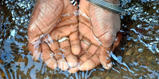
In Ngong Forest, at the source of River Mbagathi, one of the tributaries of the Nairobi River, the water is so clear, that residents drink from source, swim in it and fetch it for domestic use. When it’s not raining, they plant crops on the river bed and irrigate them with the river’s water.
However, as the river meanders downstream towards the city, things changes as farming on the banks intensifies and factories dump their effluent right in.
In Kangemi, the water is a foaming red, while farther down in Kawangware, raw sewage drains into the river from houses built on the riverbank. Here, the river changes colour from red to green, thanks to human waste. When it’s not raining, the muck settles below the houses and obstructs the flow, forming mucky pools that are breeding grounds for mosquitoes, and an overpowering stench.
At the upscale Loresho, Zein Hamid, says the river used to have fish, but not anymore. It is no longer the clean stream of his childhood, but a sewer line. Sedimentation and organic waste form the perfect fertiliser for plants in the middle of the river, and block flow, leading to flooding when it rains.
At Grogon, on Kirinyaga Road, where garages used to stand before they were demolished in April as part of the Nairobi River Regeneration campaign, the water still has an oily film; then it flows into Gikomba and Majengo, where burst sewers drain their contents into the river.

Sewerage flowing towards Nairobi River at Kamukunji. PHOTO| FRANCIS NDERITU
Things are not any better in Industrial Area, where the water takes on a darker shade from industrial waste. Garbage and structures on both sides obstruct the flow of the brackish water. Farther down in Mukuru, the informal settlement is one of the most polluted segments we have seen. The water is filthy and smelly, and residents complain that it is the factories’ fault – what with chemicals drained in the river and all – never mind that garbage and sewage from their homes are a constant part of the landscape.
Stopping at the John Michuki Memorial Park, named after the former Minister for Environment, who successfully cleaned up Nairobi River in 2009, we find an open defecation zone and hideouts for criminals. Some lovebirds relax in the overgrown grass and rusting benches, next to mounds of garbage.
Earlier this year the president announced a Nairobi Regeneration campaign, which includes restoring and rehabilitating the Nairobi River Basin. The plan even got its own Sh800 million budget, and even before the budget, the team charged with the restoration started off by demolishing structures built right on the river bank, particularly at Grogon area, just on the fringes of the Central Business District.

Kingstone and Mukuru Kwa Reuben residents have encroached on Nairobi River where they dump sewage and garbage. PHOTO| FRANCIS NDERITU
However, they stopped short of demolishing all buildings and structures standing on riparian land, obstructing river flow, and causing flooding when it rains. The secretariat added that cleanup efforts would include mapping of polluters and shutting down slaughterhouses that violate city sanitation standards.
As it is, the polluted river is a health hazard for the Kenyans who live along it, and even farther down where it joins Athi River, whose water irrigates acres of crops, putting users at risk of chemical poisoning and infections.
A study by the University of Nairobi published in 2014 noted that raw sewage and discharge from industries were the main sources of pollution, while incidences of burst sewers and garbage worsen the situation.