How drones can transform agriculture
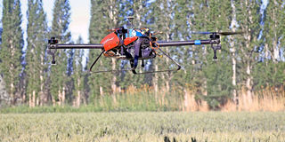
A drone flies over a wheat field to spray insecticide at a farm of the Xinjiang Production and Construction Corps (XPCC) in Bayan Gol Mongolian Autonomous Prefecture, June 9, 2015. PHOTO| XINHUA
Progressive countries have adopted drones - unmanned aircraft that flies autonomously - for precision agriculture with impressive results, but what exactly can a drone do for the agricultural sector in Africa and Kenya, in particular?
Farmers need accurate, precise and up-to-date information on plant health and environmental conditions.
On the most basic level, drones can give farmers a big picture view of their crops, allowing them to detect subtle changes that cannot be easily identified by crop scouts or extension workers on the ground.
Drones are equipped with special sensors can collect multispectral Neutral Density Vegetation Index (NDVI) and infrared images, allowing farmers to view crop changes that are otherwise invisible to the human eye.
Agricultural aircraft have been in use since the 1920s, while satellites, located thousands of kilometres away from the earth came in later to give agriculture experts a bird’s eye view of crop health.
While drones are unlikely to entirely replace manned aircraft or satellites, they have a number of advantages. They are capable of collecting very high resolution imagery below cloud level with much better detail than the satellite images usually available to analysts in African countries.
Drones can also be used in mapping and surveying. Through GIS they can provide farm boundary delineations and crop area calculations. They can also come up with a crop inventory which gives tree crop count and yield estimations through biomass indexing.
SCOUTING
Drone technology can also be used in crop scouting to identify specific crop stress and assess biomass development. Such data can help insurers assess crop damage and enhance crop management advisory, by giving the farmer up-to-date information on say, fertilising his crop.
“With the Nitrogen Nutrition Index (NNI), drones can solve the way fertilisers are applied because they can give exact timings and quantity of fertiliser needed per crop especially for crops whose quality declines with too much nitrogen.
“Moreover, most farmers do not know at what point to apply fertiliser for optimum results,” says Hamza Rkha Chaham, a drone software processing consultant.
Drones can also assist farmers in ascertaining their credit-worthiness via the integration of farmer profiles with high-resolution images, crop diagnostics, and accurate and up-to-date geo-referenced data sets.
In a recent case study in Tanzania, a team of researchers from the International Potato Centre used a drone mounted remote-sensing technology to obtain data on sweet potato varieties.
Through spectral signature the researchers were able to identify whether a crop is sweet potato, cassava or something else and were able to determine the crop variety.
The spectral signature was further able to reveal whether individual plants were water-stressed, nutritionally deficient or under attack by insects or viruses. Such changes can be detected in drone images before they can be seen by the human eye.
According to Everina Lukonge, a plant breeder, when there is no data on crops, one cannot estimate production, but with data gathered from drones, it is easier to plan.
“You can estimate yield, and in turn whether there will be famine or a bumper harvest,” she said.
Given that drone technology is available locally, farmers may soon tap into data-enabled precision agriculture from the skies.