Why the January rains and what to expect

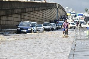
Usually, January is a dry month in Kenya, but not in 2020. Data shows that January 2020 was the wettest compared to all others from 1981 to 2010. PHOTO | FILE | NATION MEDIA GROUP

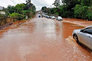
It is beginning to look a lot like March. The rains that have been pounding the country from January have left many Kenyans confused about the seasons.
For many 20-something-year-olds, who were not born between 1997 and 1998 when heavy rains struck Kenya with a furiousness not witnessed before, January this year was unusually wet. They are not the only ones baffled by this. Those born before them have also been wondering whether they are witnessing a repeat of the 1997 phenomenon, popularly referred to as El Nino.
Usually, January is a dry month in Kenya, but not in 2020. Data shows that January 2020 was the wettest compared to all others from 1981 to 2010.
Scientists are now linking this confusing weather to a phenomenon called the Indian Ocean Dipole (IOD), also referred to as the Indian Nino. It refers to the difference in sea surface temperatures on opposite sides of the Indian Ocean.
“What is happening could be a continuation of the effect of IOD and can go on for months. In 2019, the heavy rainfall experienced was because the IOD was positive,” says David Adegu, assistant director for climate services at Kenya Meteorological Department (KMD).
The IOD is equivalent to El Nino, which is the warming of the sea surface in the tropical eastern Pacific Ocean. The opposite is La Nina, meaning that when the tropical eastern Pacific Ocean is warm, the tropical western Pacific Ocean is cold. The result is rain on the eastern side and drought on the western side.
So, how does called IOD work?
The IOD influences weather and rainfall patterns over land. IOD could be positive, neutral or negative, depending on the temperature on the sea surface. When IOD is positive on the western Indian Ocean, where Kenya is located, it means the sea surface temperature is above normal in that region. As a result, the ocean water becomes warm, evaporates, cools, condenses to form clouds and comes down as rain.
When the western side of the ocean is positive, the opposite happens on the eastern side, where countries like Australia lie. A negative IOD means sea surface temperature is below normal. Because of the low temperatures, the ocean water becomes cold and heavy and cannot evaporate to form rain. The result of a negative IOD is depressed rainfall or drought. The high temperatures in Australia, which have triggered bushfires, have linked to this.
A neutral dipole means the sea surface temperature is normal.
GLOOMY FUTURE
According to experts, although the current Indian Nino is dying out — temperature is going back to normal — it is still positive (slightly higher temperatures) by at least 0.4 degrees Celsius.
Dr Abubakr Babiker, a meteorologist and climate scientist at IGAD Climate Prediction and Applications Centre in Nairobi, says warm temperature on the ocean has increased moisture supply to the region and may have contributed to the rainfall in January. He adds that the green vegetation cover across the country is also contributing to moisture recycling through evaporation. Once the moisture rises up, it cools down, condenses and comes down as rainfall, the same way it happens on the ocean.
“This is one of the strongest states of the Indian Nino. The Indian Ocean has been warming rapidly due to climate change during the past 18 years. It actually is the fastest warming part of the tropical oceans,” says Dr Babiker.
He explains that IOD moves from positive to neutral to negative or vice versa due to years and decades of changes of climate systems. He says humans have a role to play in these changes. Their activities can either harm or heal the environment, therefore, affecting the climate.
“A dipole occurs because of ocean circulation. Sometimes cold ocean water comes up on the sea surface and warm water goes under and vice versa,” says Dr Babiker. These movements affect seasons, according to research.
Although the ocean temperatures are not as high as they were in October, November and December last year, scientists say the slight change will cause enhanced March-April-May rainfall. This is because the phenomenon is not expected to die out until the end of the long rains.
Researchers at the meteorological department say it was in 2019 that Kenya recorded the strongest IOD since 1961. The sea surface temperature was above the normal range by between 0.86 degrees Celsius and 2.06 degrees Celsius. It was even stronger than 2015, which had stood out after the 1961 occurrence.
So far, Kenya has had 11 episodes of a positive IOD from 1961. The others occurred in 1963, 1972, 1982, 1983, 1994, 1997, 2006 and 2012. “The western Indian Ocean had been warming from May 2019 and peaked in October 2019, causing the heavy rainfall and the flooding witnessed late last year in Kenya and other regions in East Africa. The short rains prolonged until January and February 2020,” says Mr Adegu.
Dr Babiker says most of their reports point to a gloomy future. “Climate change will lead to extreme weather events,” he says, adding that currently, the world has already surpassed the one degree global warming above the pre-industrial levels (year 1850) agreed on.
YEAR OF CYCLONES
To avert a global crisis, countries that signed the 2015 Paris Agreement vowed to cap emissions to limit global warming to 1.5 degrees Celsius above pre-industrial levels. However, they are not on track to meet that goal.
“For example, 2019 was a special year. We started it with drought and a delayed long-rains season and ended it with heavy rainfall during the short rains. Increased global warming will lead to increased frequencies of these weather events,” says Dr Babiker.
The IOD is not the only culprit in this weather mess. Winds also had a part to play in the January rains, say experts. Wind has been blowing from the east to the west, bringing rain on the mainland.
Rainfall is also influenced by cyclones which either draw away or bring in rainfall. Cyclones are used to refer to winds that rotate around an area of low pressure. They are formed due to pressure differences on the ocean surface.
For example, in May 2019, Cyclone Idai prolonged dry season in Kenya by pushing away the rain-bearing belt. As a result, the onset of the long rains was delayed and the season was short. But, Cyclone Pawan in Somalia brought rain to Kenya.
PATTERN CHANGE
What then should we expect?
“This is the cyclone season and we expect occasional interruptions due to these cyclones,” said Ms Stella Aura, director of meteorological services at KMD during a recent press conference.
According to the weatherman, there will be three to five cyclones before the end of the oncoming rainfall season. However, the cyclones are not expected to be strong and may not affect rainfall in Kenya. “If the cyclones take a wrong track, there could be episodic dry spell within the region,” explains Mr Adegu.
With the latest prediction showing there will be enhanced rainfall during the long-rains season, he adds that it is not a must for drought to come immediately after heavy rains.
Principal meteorologist at the weather department Patricia Nying’uro says the frequency of droughts and floods has increased over the years. “We are having shorter seasons, late onsets and early cessation,” she says, adding that temperatures have been increasing while the rainfall amounts have been reducing annually.
While it rained in January and February, she says, it does not mean the seasons have changed. It only shows there have been inconsistencies in the onset and cessation of the rain seasons due to climate change. She is, however, quick to add there appears to be a pattern shift.
The latest weather forecast shows the current rain will continue to pound the Lake Victoria basin, and Rift Valley with a likelihood of increased intensity from the first week of March to continue into June.
Dr Babiker clarifies that the rains we are witnessing are not to be confused with long-rains. “While it is raining in other areas of the country, the long-rain season has not yet started and farmers should not rush to plant. They should wait until the real onset of the season,” he says.
AFLATOXIN THREAT
When HealthyNation toured Mwala, Machakos County, farmers were clearing green maize stalks from their farms in order to plant again.
The stalks had failed to dry due to incessant rainfall that has been pounding the region from October 2019 until now.
Paul Mutua, a farmer, said he had to clear the stalks despite the fact that cobs were not dry to cultivate again oblivious of the danger involved. “The rain has failed to stop. We may as well plant new crops,” he said, adding that it was unusual to have rainfall in January over the region.
The moist maize in high temperatures and high humidity may grow the Aspergillus flavus fungus which causes aflatoxin, a poisonous substance.
According to the World Health Organisation “aflatoxins pose a significant economic burden, causing an estimated 25 per cent or more of the world’s food crops to be destroyed annually”.
The onset of the long-rains is expected on the third and fourth week of March in Kajiado, Kitui, Makueni, Machakos and Tana River and most regions in the country.
Scientists have, therefore, warned Kenyans against planting before then.
“The danger is that the current rain may disappear and the crops will wither before the season starts, or may be destroyed by flooding,” said Dr Babiker.
The latest weather prediction shows most regions in Kenya will receive enhanced long-rains.
This is also expected to lead to increased diseases such as malaria in malaria-endemic zones of Coast, Nyanza and Western and waterborne diseases such as cholera due to flooding. People have, therefore, been advised to take precautionary measures such as sleeping in mosquito nets.
Heavy rainfall also bring with it Narrow bee flies (Nairobi Fly), beetles which produce a corrosive substance known as pederin and which causes blistering if it is crushed against the skin. Heavy rainfall provides a conducive environment (rotting leaves) for them to lay eggs. Instead of crushing them, it is advisable to blow them away from the skin, or gently brush them off to avoid getting an itch and blisters.
LOOKOUT FOR ALERTS
Unfortunately, the current locust invasion is expected to reduce crop yields, according to Food and Agriculture Organisation.
But due to the unpredictability of the weather, the experts advised Kenyans to be on the lookout for alerts and advisories and use climate and weather information. The information has been devolved to the counties and Kenyans are expected to access it from TVs, radio and public forums.
“Anything unexpected will be communicated through advisories,” said Mr David Adegu, Assistant Director for Climate Services at KMD.
According to an expert, the systems indigenous people used to predict weather have changed due to climate change. Therefore, integrating scientific and indigenous climate knowledge was the most appropriate thing to do to counter this.