Kenyan laws define riparian land as being a minimum of six metres and up to a maximum of 30 metres on either side of a river bank from the highest water mark.
This distance is based on the width of the river and the water volume at any given time.
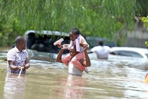
Environmentalists say flooding in Nairobi is partly caused by encroachment on waterways and riparian reserves.
For most Nairobians, rainfall is something they receive with mixed emotions. They are happy the dust is finally gone, but many times, they have woken up to floods. Here, when it rains, it floods. Literally.
While this has been partly blamed on excessive rainfall, environmentalists have been consistent in their assertions, pointing the finger in the direction of encroachment on waterways and riparian reserves.
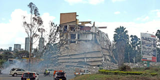
Perhaps it is for this reason that the government, through the Nairobi Regeneration Initiative, in April this year, faced up to the mess that is illegal developments, consequently demolishing buildings put up on riparian and road reserves, including a number of well-established brands. Before then, the issue had always been swept under the carpet.
If the current rate of construction is anything to go by, Nairobi, and indeed other cities, are slowly becoming concrete jungles, with open spaces where running water would otherwise percolate into the ground, dwindling.
While there is nothing particularly wrong with building houses, or the growth of property industry in general, said to contribute to the tune of 14 per cent to GDP, doing so in the wrong places can be detrimental, with death the highest price to pay, as has been witnessed in past flash floods.
WHAT IS RIPARIAN LAND?
The goings-on raise a number of questions: what exactly is riparian land? Who owns it? Why is it important to safeguard riparian reserves and in case that does not happen, what are the effects?
Mr Samwel Omesa, an environmental scientist and campaign assistant at Greenpeace Africa. PHOTO | COURTESY
To help us understand why riparian zones really matter, we spoke to Mr Samwel Omesa, an environmental scientist and campaign assistant at Greenpeace Africa—an international movement of people acting to protect the environment through peaceful campaigns and creative confrontation to expose environmental injustices around the world. Greenpeace Africa also develops solutions for a green and peaceful future.
Mr Omesa argues that there is no universally accepted definition for a riparian area, saying that the term has often been applied to fully or partially vegetated areas adjacent to rivers and streams, including, but not limited to, river and stream beds and banks.
But according to the United States Department of Agriculture, riparian areas are lands that occur along watercourses and water bodies. They are distinctly different from surrounding lands because of unique soil and vegetation characteristics that are strongly influenced by the presence of water.
At home, Kenyan laws define riparian land as being a minimum of six metres and up to a maximum of 30 metres on either side of a river bank from the highest water mark.
This distance is based on the width of the river and the water volume at any given time.
“Healthy riparian areas may have any combination of trees, shrubs, grasses, depending on the local conditions,” Mr Omesa says.
So, why is it important that we safeguard the riparian zones?
Trap sediment
By slowing the flow of water, riparian areas help to ensure that sediments settle out before they reach the water course. Mr Omesa notes that riparian areas are the last line of defence for water that is running off the land and into the lakes and streams, ensuring its quality.
Filter and buffer water
In addition to removing sediments, riparian vegetation can also trap nutrients and microscopic pathogens that are present in runoff. Studies have shown that a high percentage of pathogens and pollution-causing nutrients in runoff water can be removed by healthy riparian “buffer zones”, offers Mr Omesa.
A bulldozer hired by Oshwal Centre brings down a canal that passes through the centre's compound. PHOTO | FILE
Store flood water and energy
One of the things most developers who encroach on riparian areas don’t know or choose to ignore is the fact that flooded riparian areas act as a safety valve in the watershed because they slow water flows, reduce the size of a flood further downstream and the destructive power of fast-flowing water, Mr Omesa notes. He adds that an important factor to note here is that when the speed of water doubles, its ability to erode increases four times and its ability to carry sediments increases 64 times.
Recharge groundwater
Late last year, the South African government was staring at the prospect of Cape Town, its largest city, running out of water, prompting measures such as reusing shower water, limiting toilet flushing and night-time irrigation in an effort to save the country’s second city from running dry.
As climate change bites, cities across the globe will find themselves grappling with the problem of water shortage. Even those who will opt to sink boreholes, the sinking deeper into the ground of the water table will make it a Herculean task to reach.
So, can riparian zones help salvage the situation? “Yes, riparian areas can help to maintain local water tables, coming in handy in recharging groundwater,” Mr Omesa says.
Maintain biological diversity
If the country were to maintain its biological diversity, then the importance of safeguarding the riparian zones cannot be overemphasised.
Mr Omesa points out that in the prairie landscape, it has been estimated that riparian areas, which make up less than five per cent of the land area, hold the majority of the remaining biological diversity. In fact, he adds, in some regions, riparian areas are the only remaining natural areas.
Source of livestock food
Riparian area vegetation can be harvested in a sustainable manner to provide forage for livestock or high-value hardwood lumber.
While flooding and the resulting erosion are common forces that shape the riparian area, it is changes made by people that often have long-term adverse effects on riparian areas.
Human beings’ most common disturbance to riparian areas involves clearing vegetation and converting the area to other uses such as cropland and urban land. For farmlands, excessive logging can strip the banks of vegetation while livestock farmers should be on the lookout for overgrazing in riparian areas since this reduces the vegetation cover and tramples stream banks.
“Building dams across channels, building levees, and the channels of the streams may have the most adverse impact. These modifications significantly alter the movement and storage of water that is so important to the riparian system. Water withdrawals from streams may also reduce base flow, depriving riparian areas of moisture,” Mr Omesa says.
Development for recreational purposes can destroy natural plant diversity and structure, leading to soil compaction and erosion, and disturb wildlife.
Additionally, land use changes, paving, or removal of vegetation quicken water flow from a watershed through a riparian zone, increasing the frequency and duration of flooding.
The partly demolished Southend Mall in Nairobi on August 30, 2018. PHOTO | FILE
Law on Riparian Land in Kenya
Mr Omesa views the biggest problem with preservation, protection and management of riparian areas as fragmentation of law on riparian land, which leads to overlapping mandates and lack of coordination in enforcement.
Such laws include the Environment Management and Coordination Act (Emca) 1999, the Water Quality Regulations (WQR) (2006), Water Resources Management Rules (WRMR) (2007), the Agricultural Act (Cap318), Forest Act, 2005, Land Act 2012, Water Act, 2002, and Wildlife (Conservation and Management) Act 2013.
A closer look at the laws reveals that nearly all of them contradict each other on the recommended riparian distance. For instance, Environmental Management and Coordination (water quality) regulations, 2006, puts the recommended riparian distance at a minimum of six metres and a maximum of 30 metres from the highest water mark.
Interestingly, the Agriculture Act CAP 318 recommends a minimum of two metres and a maximum of 30 metres. It, however, does not indicate from what point.
The Survey Act 1989 recommends 30 metres from tidal rivers, but does not mention other rivers. The Part Development Plan of 1968 indicates a minimum of 30 metres from Nairobi River between Museum Hills and Racecourse roundabout.
For other rivers, the development plan recommends a minimum of 10 metres and maximum of 50 metres.
As regards ownership, Article 67 of the Kenyan Constitution says riparian land is public land, hence should not be allocated to anyone.
However, Article 62 notes that all rivers, lakes and all land between high and low water marks are public land. This means that even if a river cuts across your land, you do not have the right to own or use it. The recent demolitions are being done in line with the Environment Management and Coordination Act.
***
How to avoid falling prey to riparian land sellers
The Shell Petrol station and a Java Restaurant in the upmarket Kileleshwa estate in Nairobi became ground zero when the government begun a crackdown on buildings encroaching on riparian reserves. Many more have fallen, including major establishments such as the Ukay Mall, South End Mall, and Gateway Mall, all in Nairobi, with more than 4,000 buildings in Nairobi County set for demotion.
Property demolitions cause untoward suffering to not just the direct investors, but to others in the value chain as well. For starters, it could lead to loss of lifetime investments, jobs when businesses are shut down and family disruptions. Worse still, it has the capacity to reduce investor confidence in the property market, especially considering that a majority of those demolished buildings were approved by relevant government agencies.
So, going forward, whether you are buying land to build on it or as an investment for the future, taking deliberate steps to ensure that you don’t burn your fingers by buying riparian land will be paramount. For rural farmers, safeguarding riparian zones is equally important.
To give insight on how to avoid buying riparian land, DN2 spoke to Mr Reuben Kimani, the CEO, Username Investment Ltd, a Westlands-based land selling company, and Mr Stephen Ambani, licensed land surveyor and former Institute of Survey of Kenya chairman.
Mr Reuben Kimani, the CEO Username Investment Ltd. PHOTO | COURTESY
Involve a qualified surveyor
Whether buying land or constructing, make it your business to involve competent professionals in the process. In the case of determining riparian reserves, Mr Kimani says, you have to involve a qualified and registered surveyor, from the word go.
“He or she is supposed to get all the necessary maps to show where the water bodies are located.”
Ambani agrees, saying that the land surveyor will re-establish the beacons, confirm the size of land, and peek through the land’s survey history before drafting a survey report.
“As he does this, the surveyor will establish whether there is any riparian land attached to the land and advice accordingly,” Mr Ambani says.
To drive his point home, Mr Kimani uses a personal example.
“Sometime this year, we were purchasing a chunk of land somewhere in Ngong when we noticed that a certain area on the big survey map had been clearly marked “water area”. We could have ignored the mark on the map but as we speak that place is a dam,” he says, adding that when you are buying land, a surveyor will help you understand some of these signs on the survey map, besides helping demarcate and leave out riparian reserves on your land.
He adds that some basic knowledge on what constitutes riparian land will enable you to ask critical questions when buying land.
A competent surveyor will also write to relevant authorities such as the National Environment Management Authority (Nema), the county government, and the Water Resources Management Authority (Warma) to confirm that the parcel of land in question is not part of riparian reserve.
“Due to discrepancies in the size of riparian reserves as dictated by different laws, it is important that all these bodies are contacted,” the land surveyor says.
For those buying land from land-selling companies, which has become common practice, ensure that the seller involved qualified surveyors during demarcation and subdivision. And while at it, be sure to make site visits, as opposed to buying land at the comfort of your office desk.
Conducting a search at the lands registry, Mr Kimani points out, is important since it will help smoke out fraudsters holding fraudulently issued titles for, say, pieces of land on riparian reserves, and passing them for genuine. A conveyancing lawyer will come in handy at this stage.
Buy land during the rainy season
While there is no specific time of the year when one should buy land, with most people preferring to do it during the dry season, buying land during the rainy is advisable.
“The best time to buy land is during the rainy season. Reason? You will find the land in the worst condition possible,” Mr Kimani says, adding that doing so will bring to your attention the susceptibility of land to flooding, among other issues.