Kenyan tech guru makes huge impact in First World
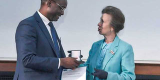
Prof Washington Yotto Ochieng receives the Harold Spencer-Jones Gold Medal in July 2019. It was awarded by the UK’s Royal Institute of Navigation. PHOTO | POOL | NATION

What you need to know:
- London-based engineering professor has helped create mapping systems that are being used in airports and high-end cars.
- Besides teaching, the centre creates solutions for transport challenges for the United Kingdom and beyond.
I am Washington Yotto Ochieng from Kendu Bay. My area of speciality is common sense.” The response from the crowd was spontaneous laughter and applause.
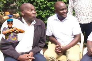
They had flocked a hall in Kenyatta University (KU) on October 25 to listen to a seven-man panel discussion, where Prof Washington Yotto Ochieng was among the panellists. His words struck them as funny because he had oversimplified his credentials, and they knew it.
For a London-based engineer who has helped create mapping systems that are being used in airports in Europe and beyond, who has played a part in developing systems found in top-of-the-range cars, and who has received several engineering awards in England, the crowd knew he was being overly modest.


The product of the University of Nairobi’s engineering class of 1988 had even omitted the “Prof” title in his name, which he has been holding for close to three decades.
IMPERIAL COLLEGE
In fact, his name is written in formal correspondence as “Professor Washington Yotto Ochieng, FREng, BSc, MSc, PhD, CEng, FICE, FCInstCES, FRIN, FCIHT”.
He did not also mention that he is in charge of a large department at the Imperial College, London, a 112-year-old institution that currently has 17,000 students and 8,000 staff, as stated on its website.
At the college, he heads the Centre for Transport Studies and also chairs the Positioning and Navigation Systems team under the Department of Civil and Environmental Engineering.
Besides teaching, the centre creates solutions for transport challenges for the United Kingdom and beyond.
As such, many in the gathering knew he had just been cursory with his introduction. After the six other panellists introduced themselves, among them Housing Principal Secretary Charles Hinga, the audience started asking questions.
Many wanted to know how Prof Ochieng could use his expertise in technology-aided navigation to solve the congestion problems facing Nairobi.
EDUCATION SAVVY
The more education-savvy people in the crowd wanted to know whether he can help them connect with universities abroad so they can get opportunities like the ones he has.
Others wanted him to shed more light on a talk he had delivered.
His talk had delved into various issues. It had a title as long as a tall frame: “Using Navigation Data in Innovative Ways to Solve Real World Problems: Some Lessons for Sub-Sahara Africa.”
In the talk, punctuated with light moments, he had given the crowd a peek into what he has been doing in his odyssey in Europe.
He had informed them about an idea he came up with that revolutionised aviation.
“I worked on a concept that we implemented in Europe. We created the system not just in Europe; but also in the US and everywhere else, and that system is now being used to navigate aircraft,” he told the attentive crowd.
BANK ACCOUNT
Prof Ochieng also discussed another innovation he helped develop. It was a project by one of his PhD students (he says he has supervised 40 PhD students so far) on refining the way electronic mapping systems show locations to a person with a map-enabled device on the ground.
“It took him four years to figure out how to do it so that the next time you are using a satnav [satellite-based navigation] and it says ‘on the next roundabout turn left’, you don’t get disappointed,” Prof Ochieng said of his PhD student.
“If you drive a state-of-the art BMW or Toyota, then you are using our map-matching algorithm in your satnav. So, please remember us (for creating it). I’ll give you my bank account,” he added, drawing laughter.
At the end of his talk, no one was in doubt that he is a specialist in the use of technology to help people explore various places on earth without using physical maps.
But he is more than that.
“I’m a multifaceted person in terms of skills,” he told a local TV station late last year.
“I’m originally in civil engineering, with a surveying background. Then later on I became a systems engineer and ended up being a space scientist. I also have a background in electoral engineering,” he added.
EDUCATION BACKGROUND
His journey to the summit of the engineering world began at Liera Primary School in Karachuonyo constituency, Homa Bay County, where he was born and raised.
After primary school, he joined Kisumu Technical High School for “O” and “A” level studies then headed to the UoN, where he graduated with a first class honours degree in engineering in 1988.
He briefly worked as an assistant lecturer at UoN before he won a scholarship that took him to the University of Nottingham in 1989. A year later, he got his Master’s with a distinction.
He enrolled for a PhD in the same university and, in 1993, he graduated as a doctor of philosophy in civil engineering, specialising in space geodesy (study of shape and the area of the earth).
As a result of his PhD studies, the University of Nottingham engaged him as a postdoctoral research associate, where he undertook research in satellite navigation.
ELECTRONICS
In 1995, Prof Ochieng joined an electronics company in the UK called Racal Electronics as a principal engineer.
While there, he led other engineers in creating the prototype, one of his most celebrated innovations that he was telling the KU crowd about. It is a navigation system called the European Geostationary Navigation Overlay Service (Egnos), the first ever satellite-based system to be used across Europe.
“(It) makes it suitable for safety-critical applications such as flying aircraft or navigating ships through narrow channels,” says a message on a website dedicated to Egnos.
“Consisting of three geostationary satellites and a network of ground stations, Egnos achieves its aim by transmitting a signal containing information on the reliability and accuracy of the positioning signals sent out by global positioning systems. It allows users in Europe and beyond to determine their position to within 1.5 metres,” it adds.
Prof Ochieng said he was the lead engineer in the project, which went live across Europe in 2009 and is being managed by the European Commission, the executive branch of the European Union (EU). It was certified for operations in 2011 and has been adopted in the US and other regions.
GALILEO NAVIGATION
“It uses geostationary satellites at 37,000 kilometres (above the earth’s surface),” he said. “What I put there is called a system architecture.”
While at Racal, the electronics company that was later acquired by Thales, he also participated in creating the initial systems of Galileo navigation system, which went live in 2016.
Galileo, which is also being owned by the EU, is used for both civilian and military operations and uses satellites to guide a person on the ground to within a centimetre of the location he or she is looking for.
After two years at Racal, Prof Ochieng joined the Imperial College London in 1997, where he has been to date. Being the current head of the college’s Centre for Transport Studies (CTS) places a huge responsibility on his shoulders.
“The CTS is one of the largest transport research groups in the world with more than 120 established academic and research staff, affiliates and research students with a multimillion pounds grant portfolio in the past five years,” says a biography Prof Ochieng shared with Lifestyle.
“It undertakes research in all modes of transport, including planning, demand modelling, design, intelligent systems, operations, logistics, safety, environment and economics,” it adds.
SCIENTIFIC JOURNALS
Through his position, Prof Ochieng says he has been a principal investigator or co-investigator in many “national and international projects totalling more than £12 million h1.6 billion)”.
As a result of his efforts in the engineering world — which include publishing more than 250 papers, with about 150 appearing in reputable scientific journals — he has received a number of honours in England.
In 2013, for instance, he was elected as one of the 60 new fellows for the Royal Academy of Engineering during an annual general meeting.
“They include some of the UK’s most accomplished engineers from academia and business,” said the academy in a statement announcing the fellows.
“Our fellowship — comprising the UK’s most eminent engineers — provides the leadership and expertise for our activities, which focus on the relationships between engineering, technology, and quality of life,” it added. In July this year, he was a recipient of the Harold Spencer-Jones Gold Medal — the highest award usually given out by the UK’s Royal Institute of Navigation, a 72-year-old institution.
RECEIVED A MEDAL
The institute said in a statement that Prof Ochieng received the medal “for pioneering research in safety-critical navigation systems”.
With all those achievements, has he ever thought of a solution that can help Kenyans on various areas of transportation?
“It is very important that we look at every case on its own merit. In the case of Nairobi, we’re dealing with a system that has grown over time, maybe in a very controlled fashion,” he told Lifestyle.
“So, we are looking at an improvement fitting the city as opposed to creating a new city. That is a bit more complex. But what we really have to go for is integrated planning. We need to look at how we could look at all the facets, all the elements of the city: Infrastructure, the people, et cetera,” Prof Ochieng added.
He recommended that there be a master plan that can create a local solution to Nairobi’s and Kenya’s other transport systems.
He also stressed on the need to have a master plan that can be discussed publicly so as to have a “city for the people” that will be adopted by all.
“We also need policies that encourage shifts; attitudinal and cultural changes towards accommodating technological solutions,” he added.
HARD WORK
“And the governance structure to deliver it needs to be in place. So, we are very clear on what the issues should be and we’re quite happy to discuss that with the powers-that-be, the relevant authorities and entities, to ensure that it is in place.”
“The warning I’m giving is, that it’s not going to be delivered tomorrow. It’s going to take time but we’re going to make sure that the processes are in place,” he noted.
Asked to discuss more about moving from Kenya to the UK, he noted that it was through hard work that he flew west.
“The actual trajectory was set off by my own initiative. So, one of the things that I’m advising young Kenyans is: Be proactive; look for opportunities. Now in the era of the Internet, there are so many potential opportunities out there. So, go out looking for them,” he said.
HELP MOTHERLAND
And so, where are we likely to find the technologies he has helped create?
“My technologies are everywhere. They’re not just in cars but also in aeroplanes. They are being used in transport systems,” he answered.
He also boasts about a decoder found in vehicles called the CANbus (controlled area network bus) with micro components that allow various components of a car to communicate without the need of a computer.
“We developed that in 2003,” he said at the KU talk. “I believe that most of the vehicles being driven on Kenyan roads today have it.”
Having been involved in various projects in Australia, Brazil, Canada, China, India, Japan, Russia among other countries, it is evident that Prof Ochieng is living the dream in matters engineering.
“Two weeks ago I was in China and Japan; and two weeks from now I’m going to Russia. I’m working on these systems. Our plan is to create a global capability,” he said.
In his speeches, he fondly refers to his hometown, Kendu Bay, and the intellectuals who have come from there — among them his family members.
As part of his desire to help his motherland, Prof Ochieng is among eight members of the programme steering committee for the five-year Sustainable Urban Economic Development Programme running from 2018.
It is funded by UK Aid to the tune of £70 million (Sh9.2 billion) and its aim is funding 12 towns through county governments — among them Eldoret, Isiolo, Iten, Kisii and Kitui — to support development of infrastructure and projects that improve locals’ livelihoods.
He is also championing the creation of a navigation system for Africa called the African Satellite Augmentation System.
“That will probably be the proudest moment when we switch that on,” he says.