Breaking News: At least 10 feared to have drowned in Makueni river
Building owners run to courts to stop demolitions
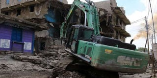
An excavator brings down a building in Mathare Area A that was earmarked for demolition, on May 17, 2016. There has always been a rush to demolish buildings considered unsafe immediately after a tragedy, only to stop once the media spotlight fades. PHOTO | JEFF ANGOTE | NATION MEDIA GROUP

What you need to know:
- More than 200 buildings, especially apartments, have been earmarked for demolition and some 2,000 titles of land in areas considered riparian reserves are set to be cancelled.
- The Ukay Centre, which houses Nakumatt supermarket, has experienced flooding whenever it rains heavily as it was allegedly constructed on a river basin.
- Some developers have constructed dykes to divert the river’s natural course and shore up their buildings.
As the demolition of unsafe buildings moves a notch higher this week, the Nairobi County Government and regulatory authorities are on the spot on whether they will go all the way and clean up the mess in the sector.
In the past, political expediency, corruption and court injunctions have slowed down such efforts.
In what has become a routine reactionary measure, there has always been a rush to demolish buildings considered unsafe immediately after a tragedy, only to stop once the media spotlight fades.


More than 200 buildings, especially apartments, have been earmarked for demolition and some 2,000 titles of land in areas considered riparian reserves are set to be cancelled.
This has put the county government on a warpath with developers, setting the stage for legal battles.
By Friday, 18 owners of buildings earmarked for demolition had managed to get court injunctions barring the county government from demolishing their structures.
The number could go higher this week if more owners, motivated by the successful injunctions, decide to also seek legal redress.
Nairobi Senator Mike Sonko, who has taken the county government to court over the recent Huruma building collapse – which killed 51 people – insists that the buck stops with Governor Evans Kidero.
“The authorities must be made to pay. In fact, the county government has already admitted liability and fired some officials,” he says.
Before a building is constructed, the developer has to seek approvals from the county government, National Construction Authority (NCA) and the National Environment Management Authority.
Among the notable buildings set to be demolished is the Ukay Centre in Westlands, and one associated with Bobasi MP Stephen Manoti that is coming up on Lang’ata Road, according to land county executive committee member Christopher Khaemba.
The Ukay Centre, which houses Nakumatt supermarket, has experienced flooding whenever it rains heavily as it was allegedly constructed on a river basin.
RIPARIAN LAND
It is unclear why previous threats to demolish the building have never been effected.
The last one was in 2009 when then Minister for Lands James Orengo declared that the shopping complex and Westgate Mall would be brought down.
Mr Manoti has already gone to court seeking orders to stop the county from demolishing his hotel but the county government insists the building will come down as it allegedly stands on Mutuini River, one of the three main drainage systems of the city.
But raising eyebrows is the fact that the list released by the county government on buildings set to come down only focuses on low-income areas, despite the fact that rivers passing through upmarket neighbourhoods are seriously encroached on.
For instance, despite a 2010 revocation of the title deed for Alina Villas, under construction on Lower Kabete Road, for being on a wetland and road reserve, the county government has been unable to retake the land on plot number LR 209/12184, associated with businessman Ayaz Meralli.
The project was stopped in 2009 but it later resumed.
“We have built on all our soft surfaces, including riparian areas, and too close to the two main drainage systems for Nairobi. Nature has its own system of conveyance and gravity,” Mr Lawrence Esho of the School of Architecture and Physical Planning at the Technical University of Kenya says.
Nairobi River runs from Kileleshwa to Westlands and crosses the city centre at the Globe Cinema roundabout before leaving to join Athi River, after traversing several estates and informal settlements in Eastlands.
FLOODING
Mutuini River originates from Ngong Forest, runs through Kibera slum into Nairobi Dam, which is supposed to act as a temporary reservoir, before heading to Nairobi West and into Industrial Area, and leaving the city through Kayole to join Athi River.
But according to a spot-check by Sunday Nation, the Nairobi River section between St Mary’s School and Church Road in Kileleshwa is heavily encroached on, with some buildings right on top of it.
Some developers have constructed dykes to divert the river’s natural course and shore up their buildings.
Flooding of the low-lying South C, Nairobi West and Madaraka areas is partly caused by a block of apartments bordering the Nairobi Dam, as its developers diverted the natural flow of water from the dam to a new spillway.