Report reveals 'big fish' who illegally acquired, sold off Mau land
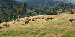
Part of Maasai Mau Forest where indigenous trees have been cut down. Details of how adjudication sections in the forest were irregularly increased, leading to encroachment, can be now be revealed. PHOTO | JEFF ANGOTE | NATION MEDIA GROUP

What you need to know:
- Ministry of Environment and Forestry explains how tens of hectares of land were surrendered to individuals fraudulently.
- The 1986 Ole Ntutu Boundary Commission had recommended some five ranches be reclaimed.
- During the sub-divisions, title deeds, now declared null and void, were issued beyond the group ranch boundaries.
Details of how adjudication sections in the Maasai Mau Forest were irregularly increased, leading to encroachment, can be now be revealed.
The Ministry of Environment and Forestry, in a report, explains how tens of hectares of land were surrendered to individuals fraudulently.
This led to illegal settlements, the major threat facing the forest, and dates back to the 1970s when the government declared five adjudication sections in the north of Olpusimoru and Maasai Mau forest, according to Cabinet Secretary Keriako Tobiko.


RECLAIM RANCHES
They are Olposimoru A and B, Kamurar, Kilapa and Olkurto. The 1986 Ole Ntutu Boundary Commission had recommended some five ranches be reclaimed from these adjudication sections as they were used to encroach into the forest.
Five other adjudication sections, Illmotiok, Ololulunga, Nkareta, Nkoben and Naisuya, were later declared to the south of the forest which led to increased pressure in the previous sections.
“The pressure on Maasai Mau Forest started again in 1999, when five forest adjacent group ranches that had been adjudicated in 1970s, applied for consent from the local Land Control Board to sub-divide their land among members,” Mr Tobi-ko says in the “Report of Cabinet Secretary on Maasai Mau Forest (Water Towers) Evictions”.
WELL-DEFINED
The affected ranches were Sisiyan (Ilmotiok Adjudication Section), Nkaroni, Enoosokon and Enakishomi (Ololulunga Adjudication Section) and Reiyo (Nkoben Adjudication Section).
According to the CS, boundaries of these sections were well-defined during land adjudication and, therefore, adopted at first registration.
But the report names government officials, politicians, private surveyors and influential people as those who irregularly increased the sizes of the ranches far be-yond their registered areas. A total of 1,089 people who originally got land within the forest excised the parcels and later sold or transferred them.
The report proposes they be held criminally liable for their decisions.
SUB-DIVISIONS
And during these sub-divisions, title deeds, now declared null and void, were issued beyond the group ranch boundaries originally in the adjudication sections.
During the sub-division of the five group ranches in Ilmotik, Nkoben and Ololunga adjudication sections in the late 1990s, title deeds were issued in excess of the group ranches originally adjudicated areas.
By 2005, illegal extension into the Maasai Mau Forest due to expansion of group ranches had created 1,962 parcels of land, amounting to 17,101 hectares of the forest.
The 17,101 ha do not include the areas covered by Nkareta adjudication section (2664 ha) and Olokurto adjudication section (1571 ha).
“If the settlers are allowed to continue inhabiting the illegally acquired forest land totalling 21,336 ha, only 24,942 ha of Maasai Mau will be left out of the total 46,278 ha. This will adversely affect the ability of the ecosystem to continuously provide the ecosystem services it does and hence reducing its ecological integrity,” warns CS Tobiko.
EVICTIONS
The ongoing eviction is to pave the way for conservation of the 46,278-hectare forest, which is one of the 23 blocks of the Mau complex. More than 40,000 settlers have refused to leave the forest. Maasai Mau is the most threatened block of the complex. The ministry’s report identifies recommendations by taskforces which have never been implemented.
These include the Kenya Water Tower Agency (2014) report and Sambu Task-force on Gazettement of Narok Forests which has not been done. The sites captured in this report were Tendwet, Olemekenyu and Nkoben.
KWTA’s report recommended that the creation of a buffer between Maasai Mau and Olposimoru forest was ill-advised as this should have been done on the edges of the forests and that the Maasai Mau issue should be handled with a conservation approach.
There is also the inter-agency assessment of biodiversity in the Maasai Mau, which proposed forest restoration and conservation programmes to preserve the important ecosystem.
However, some recommendations from Ole Ntutu Boundary Commission (1986), Ndung’u Land Commission (2004), Mau Taskforce (2008), and the Forest Task-force on forest resources management and logging activities in Kenya (2018) have been implemented.