Meteorologist explains reasons behind the heavy rainfall
What you need to know:
In the month of October, no Kenyan county recorded less than 75 per cent of their October long-term averages.
As this is usually the short rain season, the heavy rains come as a puzzle to many.
The Nation sought answers from Mr Augustine Kiptum, the principal meteorologist at Met
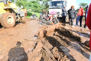
Over the past three months, most parts of Kenya have received heavy rainfall that has left more than 132 people dead and thousands displaced.
Floods, lightning strikes and landslides have been witnessed in various parts of the country, leaving behind a trail of destruction.
The Meteorological Department of Kenya, in its weekly and monthly forecasts, has predicted that the downpour will persist until the end of the month, with intermittent episodes of heavy and light rainfall in the next three weeks.


UNUSUAL RAINFALL
The review for the month of November indicated that the rainfall was generally enhanced, with most stations recording precipitation above 100 per cent of their November long-term averages.
Counties such as Mombasa recorded 289 per cent of its long-term average, while others such as Lamu, Malindi, Wajir, Narok and Mandera recorded more than 200 per cent of their long-term averages.
In the month of October, no Kenyan county recorded less than 75 per cent of their October long-term average.
As this is usually the short rain season, the heavy rains come as a puzzle to many.
The Nation sought answers from Mr Augustine Kiptum, the principal meteorologist at Met.
This season is supposed to be the short rains, why are we experiencing heavy rainfall? Is there a scientific explanation behind this?
Yes, it is true that the period between October and December is the season of the short rains.
However, the heavy, or rather enhanced, rainfall we are experiencing now is due to a number of climate drivers affecting Kenya.
Among these drivers is the Indian Ocean Dipole (IOD), also known as Indian Niño, which has been triggered by the irregular fluctuation of sea-surface temperatures such that the western Indian Ocean that borders the East African shores becomes alternately warmer and then colder than the eastern part of the ocean, leading to more storm clouds and, as a result, more rainfall in the mainland.
Apart from the IOD, are there any other atmospheric conditions that could have contributed to this?
There are various atmospheric conditions that can lead to the occurrence of heavy rainfall.
These conditions, or rather climate drivers, are often caused by different pressure fronts or zones either from the north or south.
They include conditions such as air masses, for example the Congo air mass, Lake Victoria air mass, and the Indian Ocean air mass.
There are also occurrences of tropical winds or storms such as cyclones and depressions.
Over the past few days, there have been depressions over the Indian Ocean which has, in part, contributed to the rains we are receiving.
Additionally, there are other climate drivers such as the El Niño/Southern Oscillation (ENSO), which is an irregularly periodic variation in winds and sea surface temperatures over the tropical eastern Pacific Ocean, affecting the climate of much of the tropics and sub-tropics.
There is also the Madden-Julian Oscillation (MJO) which, although not common, is an eastward moving disturbance of clouds, rainfall, winds, and pressure that traverses the tropics.
Other drivers include sub-tropical highs such as St Hellena, Arabia, Azores and Mascarine as well as the Inter Tropical Convergence Zone (ITCZ) which is a belt of low pressure which generally circles near the equator where the trade winds of the Northern and Southern Hemispheres come together.
Are other countries in East Africa also experiencing heavy rains and is this linked to climate change?
Over the past few years, we have seen a changing pattern that is moving away from the climate we used to have.
For example, the frequencies of heavy rainfall as well as episodes of drought have increased and become common.
The long-term weather patterns are affiliated to climate change and this is not just in Kenya but also in the region.
Countries such as Tanzania have been and will continue to receive heavy rainfall.
It is important that counties that are prone to drought, more so in northern Kenya, store the rain water at this time in case there is drought come early next year.
Will the current heavy rainfall have an impact on next year’s long rains season and should we be worried about food security?
It is difficult right now to determine if the long rains in March will be affected or delayed as we have not yet done the short rains review.
However, because of cases such as flooding that has been recorded in several parts of the country, farmers have lost much of their harvest and this will in turn affect our food situation.
When we do our report at the end of the year, we will be better placed to predict if the March rains will fail or if we will have incidents of drought in some parts of the country.
How much longer should we expect the rains to last?
In most parts of the country, the rains should continue for three more weeks as we close December while in some parts such as the western region — in counties such as Narok and Kisii — the rains will continue to mid-January.
The rains will start picking up as we approach Sunday in most parts of the country.
However, we are expecting that the rains will gradually decline both in frequency and intensity towards the end of December.
So far, what has been the impact of the short rains and what precautions should Kenyans take during this season?
The October, November and December 2019 rainfall has resulted in the loss of more than 100 lives as a result of floods, landslides and mudslides.
In addition, more than 160,000 people have been affected by the rains and another 18,000 displaced.
We have also seen destruction of farm crops and buildings.
Additionally, transport has been paralysed in many parts of the country.
We highly recommend that people be vigilant, heed predictions and advisories we give on a daily and weekly basis.
Those living in valleys and landslide-prone areas should move to higher grounds.
As for the national and county governments and other agencies involved in rescue and humanitarian activities, there should be increased co-ordination in rescue efforts.
As a long-term solution, the government should also ensure that infrastructure such as drainage and transport networks are in good working condition.