Thomson Falls: The town beloved by Boers and ex-soldiers

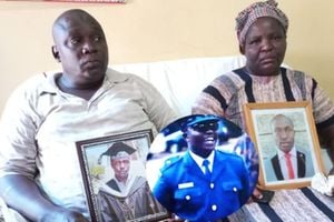
Laikipia Woman Representative Catherine Waruguru addresses faithful at Glory Christian Church in Nanyuki town on December 10, 2017. She has asked leaders to dialogue on the future of Nyahururu. PHOTO | JOSEPH KANYI | NATION MEDIA GROUP
What you need to know:
- Most of these colonial farmers had coalesced around Nyahururu town, which was serving those within its radius.
- Thomson is said to have always asked his porters and askari to seek peaceful passage of his entourage through Kenya.
- In 1967, the government rejected a motion to set up an independent commission to review the boundaries.
The first time I slept in a tent was in Thomson Falls lodge in Nyahururu — perhaps the coldest town in Kenya.
As one of the highest places in the country, standing at an elevation of 7,742 feet, it is also one of the few towns with Dutch colonial architecture and for a reason.
As Laikipia and Nyandarua politicians start a cold war on who “owns” this town — and who is entitled to revenue collected here, it is important to look at the story of Thomson Falls town — as it was known in pioneer days and why for the last 50 years there is no let up on whether it should be in Nyahururu or Laikipia.


Already, daggers have been drawn over the Sh600 million revenue collected annually from this town. Let us start from the beginning.
CHURCH
Apart from Eldoret, Thomson Falls was one of the other Kenyan town that the South African Boers, who had trekked north to escape war, founded.
There was a Dutch School – the Van Riebeck School, a church and a cemetery.
The school was initially known as Thomson’s Falls Afrikaans School but when it was officially inaugurated on April 6, 1952, it was named the Van Riebeck School, in honour of the landing of Jan van Riebeeck, the man who founded Cape Town some 300 years earlier.
When the Boers built the school in Nyahururu, they only allowed their own children to study there and followed Transvaal Education Department’s curriculum.
The church they built, Dutch Reformed Church, is today known as African Inland Church, Nyahururu, and was only reserved for them.
REBRANDED
But with the outbreak of Mau Mau war the school was abandoned as many farmers took their children away from the war zone.
After independence, it was renamed Thomson Falls High School and is now known as Ndururumo High.
Most of these colonial farmers had coalesced around Nyahururu town, which was serving those within its radius.
The Boers had little regard for the British authorities — and they made sure the administrators knew as much.
When the railway first reached here in 1929 from Gilgil, Parliament was told the idea was to open up a district whose potential was hampered by lack of communication and as Lord Delamere said, the only option was to either build an expensive all-weather road or a one-branch railway line.
RAILWAY
Lord Delamere was a Member of Parliament and had interests in Nyahururu where he had a farm.
Also, his brother-in-law Galbraith Cole, a pioneer of sheep farming in the area, had become a household name in the settler community.
Thus, the arrival of the railway saw hundreds of farmers take settlement around Nyahururu town and these were the British ex-soldiers who had fought in the First World War and were being repaid with land.
Everyone seemed to love Nyahururu — not only because of its weather — but also because it had the historic 72-metre waterfall on the Ewaso Ng’iro river found at the edge of the town.
It had been named Thomson Falls after a Scottish geologist Joseph Thompson who at an early age – he was 25 – earned reputation as one of the greatest British explorers in Africa.
POLITICIANS
As the politicians start wrangling about Nyahururu town, the words of Joseph Thomson and his famous motto: “He who goes gently, goes safely; he who goes safely, goes far” might help the protagonists.
Thomson is said to have always asked his porters and askari to seek peaceful passage of his entourage through Kenya.
And for the thousands of kilometres that he trekked looking for the route towards Lake Victoria, he was never attacked.
As a member of the Royal Geographic Society, he mapped several lakes in Kenya, including Lake Bogoria and Lake Baringo, and was the one who named Nyandarua Ridges, Aberdare in 1884 after a Scottish peer Lord Henry Campbell Bruce, 2nd Baron Aberdare who was president of the Royal Geographical Society.
He also had a gazelle, Thomson’s gazelle, named after him before he died of pneumonia aged 37 – and today, his name is mentioned alongside Mungo Park and David Livingstone.
Enough of colonial Thomson Falls — and now welcome to our Nyahururu town.
CONSTITUENCIES
For the record, Nyahururu town was always regarded as part of Laikipia District during the colonial days.
At the dawn of independence, and when the Kenya Council of Ministers (the then Cabinet) decided to delimit the constituencies in April 1963, a new Laikipia District with two constituencies — Laikipia East and Laikipia West — was created.
The problem was that when the Central Region was being created, under the Majimbo Constitution, the other tribes objected to their inclusion into an area that was predominantly Kikuyu — and that is how efforts to take Nyahururu, which was always in the Rift Valley, to Central Province collapsed at Lancaster.
Again, Jomo Kenyatta’s Kanu had grudgingly accepted Majimbo system propagated by KADU in order to defeat any delay towards independence.
While Nanyuki town was, during colonial days, part of Aberdare District, the creation of a new Nyandarua District — from Aberdare District, Naivasha and Nakuru — also left Nanyuki inside Laikipia since it was not inhabited by Kikuyus.
This meant the new Nyandarua district did not have a town that could house the central government’s administration.
BOUNDARIES
In essence, a district in central province was having its headquarters in the Rift Valley!
What looked like a short-term sojourn turned into years — and the camel’s nose was now under the tent.
When the matter was first raised in Parliament by Mr Willy Kamuren, the Minister of State in the office of the President, James Nyamweya said the problem was that there was no place to locate the administration.
He said: “Since the old regional assembly days, the new district of Nyandarua was being administered, for administrative purposes, from Thomson’s Falls, the reasons being that in the whole of Nyandarua there was not a suitable “place where the new district could have been administered from”.
The case of Nyandarua was a first, although Thika town — previously a sub-district of Nairobi — had faced a similar dilemma, on whether it was in Kiambu or Murang’a.
The matter was settled when Jomo Kenyatta issued a decree that it should be administered by Kiambu.
NYAHURURU
Rather than build a new district for Nyandarua, the government decided to build new Nyandarua district headquarters in Nyahururu and in 1966 they put aside £50,000 for the project.
The thinking then — and Mr Nyamweya said as much — was that building a new headquarters for Nyandarua would have cost £300,000 “and this would neither be justified nor reasonable, particularly if it is possible to find alternative accommodation which is not fully utilised at present.”
With the collapse of regional governments in 1964, nobody ever saw a time when problems would later arise.
The residents of Nyandarua always regarded Nyahururu as their own town and invested in it.
But since a change in boundaries would have required constitutional changes — the Kenyatta government was shy to do that lest it was accused of taking a Rift Valley town to Central Province.
ETHNIC TENSION
The problem was that such a move would have complicated political relationships between Central Province and Rift Valley — and increase tension between Kikuyu on the one hand and Kalenjin and Maasai, on the other, over land.
In 1967, the government rejected a motion to set up an independent commission to review the boundaries with Mbiyu Koinange, the Minister of State and Kenyatta’s right-hand man, saying the proposals put forward by Laikipia East MP GG Ndegwa were causing grave concern.
He said a few politicians wanted to make their areas larger.
Mr Ndegwa had argued the boundaries were delimited by the former colonial government to suit its policy of divide and rule.
“It was done when the colonialists found it necessary to put a certain area in another part of a district so that it could be ruled easily and Europeans could have their own area away from the Africans,” he told Parliament.
MISCHIEF
Ndegwa was one of the politicians who wanted the Kenyatta government to take Nyahururu to Nyandarua.
In 1977, the local government minister appointed a committee to redistribute assets of the former Urban Council of Thomson Falls (renamed Town Council of Nyahururu) and those of the County Council of Nyandarua to allow each to maintain its own assets.
The hope then was that it would solve the problems but then came the political mischief of the Nyayo era.
In the 1990s when local kingpin GG Kariuki was enjoying immense power as the Kanu chairman for Laikipia District, the idea of creating a new district for Nyandarua in the sleepy Ol Kalou town was hatched.
It had even been floated that Nyahururu could become part of Koibatek District and one Nyandarua MP said as much in Parliament.
Ol Kalou had no piped water and no amenities by the time President Moi announced that it would be the new Nyandarua headquarters.
SCHOOL
There was also confusion since institutions within Nyahururu town were registered as either belonging to Nyandarua or Laikipia.
For instance, Nyahururu High School, was always thought to be in Central Province, although physically in Laikipia.
“How are we going to make sure Nyahururu High School is going to remain in Nyandarua when it is actually in Laikipia District,” then Ndaragua MP Thirikwa Kamau ondered.
The matter was more complex than that: “All along, and as far as the people of Nyandarua have known, this town called Nyahururu has been in Nyandarua District.
"Now, that there has been a government decision to move the district headquarters to Ol Kalou, we are requesting that, because a lot of money has been spent by the people of Nyandarua to develop Nyahururu town, we would like the government to take up its responsibility and build the district headquarters in Ol Kalou town,” Eng Muriuki Karue, then Ol Kalou MP, said.
REVENUE
At the moment, Nyahururu town is in Laikipia County — and the battle for scarce revenue is on.
The argument, and the Nyandarua people have a right to feel conned, is that for years, they had invested in Nyahururu town as their own and with the town as the cash cow for Laikipia, they have no share of the Sh600 million revenue generated here.
The matter was raised recently by the Laikipia Woman Representative Catherine Waruguru who asked the leaders to dialogue on the future of Nyahururu.
Ol Kalou MP Njuguna Kiaraho and Jeremiah Kioni (Ndaragwa) are to lead a team to spearhead the agenda of the relocation of the town.
DEVOLUTION
The Deputy President William Ruto has already told off the Nyandarua and Laikipia leaders. Six days ago, he told them to stop bickering over the town.
“Nyahururu is in Kenya and you’re all Kenyans,” Ruto said.
Last year, Nyandarua Governor Francis Kimemia mourned the loss of Nyahururu and said his county was using money meant for development to house its staff:
“At a time when other counties enjoyed huge infrastructure at their disposal, inherited mainly from defunct local authorities, Nyandarua had none of these as our facilities were locked up in Nyahururu town – the former district headquarters – which was transferred to Laikipia County.”
Nyahururu town is a classic case of gerrymandering, intrigues, and political backstabbing at its best.
If you want to understand Kenya’s politics, re-read the history of Nyahururu town.